Ise geodata
Ise (Mie) is a seat of a second-order administrative division; located in Japan in Asia/Tokyo (GMT+9) time zone. With population of 97,314 people, there are 208 cities with bigger population in this country. Compared to other cities in Japan, 73% of cities are located further ↑North; 56.1% of cities are located further →East and 64.2% of cities have lower elevation than Ise. Note1


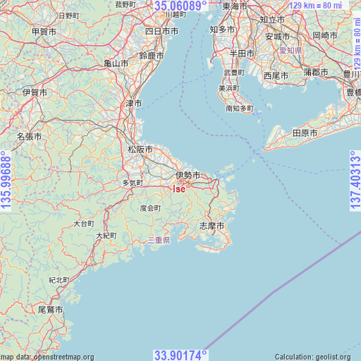
Ise GPS coordinates[2]
34° 28' 59.988" North, 136° 42' 0" East
| Map corner | latitude | longitude |
|---|---|---|
| Upper-left | 35.06089°, | 135.99688° |
| Center: | 34.48333°, | 136.7° |
| Lower-right: | 33.90174°, | 137.40313° |
| Map W x H: | 128.9×128.9 km | = 80.1×80.1mi |
| max Lat: | 45.40944° ⇑73% North |
| Ise: | 34.48333° |
| min Lat: | ⇓27% South 24.34478° |
| min Long | Ise | max Long |
| 123° | 136.7° | 145.575° |
| W 43.9%⇐ | ⇒56.1% E |
Elevation
Elevation of Ise is 56 m = 184 ft, and this is 28.6 m = 94 ft below average elevation for this country.
| Max E: |
1086 m = 3563 ft | 35.8% |
| Avg. | 84.6 m = 278 ft | |
| Ise | 56 m = 184 ft | |
Min E: |
-2 m = -7 ft | 64.2% |
See also: Ise elevation on elevation.city.
Geographical zone
Ise is located in North temperate zone (between Tropic of Cancer and the Arctic Circle). Distance of this Northern Tropic circle is 1228.3 km =763.2 mi to South.| Distance of | km | miles | from Ise |
|---|---|---|---|
| North Pole | 6172.9 | 3835.7 | to North |
| Arctic Circle | 3567 | 2216.4 | to North |
| Tropic Cancer | 1228.3 | 763.2 | to South |
| Equator | 3834.2 | 2382.5 | to South |


Nearby cities:
15 places around Ise: (largest is in red/bold)
• Hisai-motomachi
29.5 km =18.3 mi,  313°
313°
• Ishiki
45.6 km =28.3 mi,  39°
39°
• Kameyama
46.7 km =29 mi,  330°
330°
• Kasado
47.9 km =29.8 mi,  341°
341°
• Kawage
38.4 km =23.9 mi, 338°
• Kihoku
45.2 km =28.1 mi,  227°
227°
• Matsusaka
18.3 km =11.4 mi, 305°
• Minamiise
14.9 km =9.3 mi,  180°
180°
• Shima
20.7 km =12.9 mi,  143°
143°
• Suzuka
45.7 km =28.4 mi,  346°
346°
• Taketoyo
45.3 km =28.1 mi,  25°
25°
• Toba
13 km =8.1 mi,  90°
90°
• Tokoname
46.5 km =28.9 mi,  17°
17°
• Toyohama
33 km =20.5 mi, 40°
• Tsu
32.5 km =20.2 mi, 328°
Sources, notices
• [Note1] Compared only with cities in Japan existing in our database
• [Src1] Map data: © OpenStreetMap contributors (CC-BY-SA)
• [Src2] Other city data from geonames.org with taken over terms of usage.
• [Src3] Geographical zone / Annual Mean Temperature by Robert A. Rohde @ Wikipedia
