Kihoku geodata
Kihoku (Mie) is a seat of a third-order administrative division; located in Japan in Asia/Tokyo (GMT+9) time zone. In our database, there are 767 cities with bigger population. Compared to other cities in Japan, 77.4% of cities are located further ↑North; 58.9% of cities are located further →East and 89.6% of cities have higher elevation than Kihoku. Note1


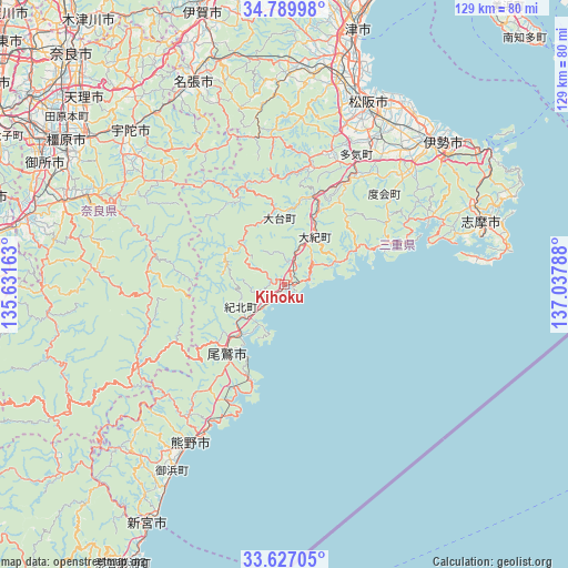
Kihoku GPS coordinates[2]
34° 12' 37.872" North, 136° 20' 5.1" East
| Map corner | latitude | longitude |
|---|---|---|
| Upper-left | 34.78998°, | 135.63163° |
| Center: | 34.21052°, | 136.33475° |
| Lower-right: | 33.62705°, | 137.03788° |
| Map W x H: | 129.3×129.3 km | = 80.3×80.3mi |
| max Lat: | 45.40944° ⇑77.4% North |
| Kihoku: | 34.21052° |
| min Lat: | ⇓22.6% South 24.34478° |
| min Long | Kihoku | max Long |
| 123° | 136.33475° | 145.575° |
| W 41.1%⇐ | ⇒58.9% E |
Elevation
Elevation of Kihoku is 5 m = 16 ft, and this is 79.6 m = 261 ft below average elevation for this country.
| Max E: |
1086 m = 3563 ft | 89.6% |
| Avg. | 84.6 m = 278 ft | |
| Kihoku | 5 m = 16 ft | |
Min E: |
-2 m = -7 ft | 10.4% |
See also: Japan elevation on elevation.city.
Geographical zone
Kihoku is located in North temperate zone (between Tropic of Cancer and the Arctic Circle). Distance of this Northern Tropic circle is 1197.9 km =744.3 mi to South.| Distance of | km | miles | from Kihoku |
|---|---|---|---|
| North Pole | 6203.2 | 3854.5 | to North |
| Arctic Circle | 3597.3 | 2235.3 | to North |
| Tropic Cancer | 1197.9 | 744.3 | to South |
| Equator | 3803.9 | 2363.6 | to South |


Nearby cities:
15 places around Kihoku: (largest is in red/bold)
• Gojō
60.3 km =37.5 mi,  284°
284°
• Haibara-akanedai
50.4 km =31.3 mi,  315°
315°
• Hisai-motomachi
52.1 km =32.4 mi,  13°
13°
• Ise
45.2 km =28.1 mi,  47°
47°
• Kashihara-shi
59.8 km =37.2 mi,  303°
303°
• Kumano
39.3 km =24.4 mi,  209°
209°
• Matsusaka
45 km =28 mi,  24°
24°
• Minamiise
36.9 km =22.9 mi,  65°
65°
• Nabari
50.7 km =31.5 mi,  332°
332°
• Owase
20.2 km =12.6 mi,  217°
217°
• Sakurai
54.9 km =34.1 mi,  305°
305°
• Shima
47.8 km =29.7 mi, 73°
• Toba
55.6 km =34.5 mi,  56°
56°
• Yoshino-chō
48.4 km =30.1 mi, 295°
• Ōuda
46.6 km =29 mi, 307°
Sources, notices
• [Note1] Compared only with cities in Japan existing in our database
• [Src1] Map data: © OpenStreetMap contributors (CC-BY-SA)
• [Src2] Other city data from geonames.org with taken over terms of usage.
• [Src3] Geographical zone / Annual Mean Temperature by Robert A. Rohde @ Wikipedia
