Seto geodata
Seto (Aichi) is a seat of a second-order administrative division; located in Japan in Asia/Tokyo (GMT+9) time zone. With population of 134,246 people, there are 151 cities with bigger population in this country. Compared to other cities in Japan, 53.6% of cities are located further ↑North; 50.6% of cities are located further →East and 78.7% of cities have lower elevation than Seto. Note1


Seto GPS coordinates[2]
35° 13' 59.988" North, 137° 6' 0" East
| Map corner | latitude | longitude |
|---|---|---|
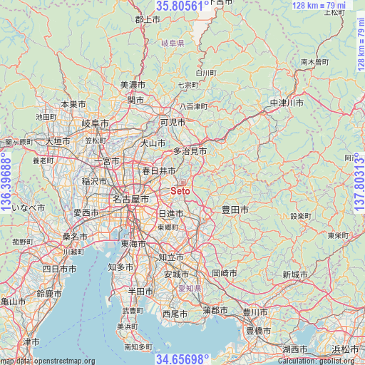
| Upper-left | 35.80561°, | 136.39688° |
| Center: | 35.23333°, | 137.1° |
| Lower-right: | 34.65698°, | 137.80313° |
| Map W x H: | 127.7×127.7 km | = 79.3×79.3mi |
| max Lat: | 45.40944° ⇑53.6% North |
| Seto: | 35.23333° |
| min Lat: | ⇓46.4% South 24.34478° |
| min Long | Seto | max Long |
| 123° | 137.1° | 145.575° |
| W 49.4%⇐ | ⇒50.6% E |
Elevation
Elevation of Seto is 111 m = 364 ft, and this is 26.4 m = 87 ft above average elevation for this country.
| Max E: |
1086 m = 3563 ft | 21.3% |
| Seto | 111 m 364 ft | |
| Avg. | 84.6 m = 278 ft | |
Min E: |
-2 m = -7 ft | 78.7% |
See also: Seto elevation on elevation.city.
Geographical zone
Seto is located in North temperate zone (between Tropic of Cancer and the Arctic Circle). Distance of this Northern Tropic circle is 1311.7 km =815.1 mi to South.| Distance of | km | miles | from Seto |
|---|---|---|---|
| North Pole | 6089.5 | 3783.8 | to North |
| Arctic Circle | 3483.6 | 2164.6 | to North |
| Tropic Cancer | 1311.7 | 815.1 | to South |
| Equator | 3917.6 | 2434.3 | to South |


Nearby cities:
15 places around Seto: (largest is in red/bold)
• Inuyama
21.7 km =13.5 mi,  318°
318°
• Iwakura
21.9 km =13.6 mi,  284°
284°
• Kani
19.4 km =12.1 mi,  348°
348°
• Kasugai
11.7 km =7.3 mi, 277°
• Kitanagoya
20.2 km =12.6 mi,  274°
274°
• Komaki
17.5 km =10.9 mi,  288°
288°
• Mitake
20.6 km =12.8 mi,  8°
8°
• Miyoshi
16 km =9.9 mi,  183°
183°
• Mizunami
20.1 km =12.5 mi,  42°
42°
• Nagakute
7.8 km =4.8 mi,  210°
210°
• Nagoya
18.5 km =11.5 mi,  251°
251°
• Nisshin
11.6 km =7.2 mi,  201°
201°
• Tajimi
9.7 km =6 mi,  18°
18°
• Toki
15 km =9.3 mi,  30°
30°
• Toyota
17.3 km =10.7 mi,  164°
164°
Sources, notices
• [Note1] Compared only with cities in Japan existing in our database
• [Src1] Map data: © OpenStreetMap contributors (CC-BY-SA)
• [Src2] Other city data from geonames.org with taken over terms of usage.
• [Src3] Geographical zone / Annual Mean Temperature by Robert A. Rohde @ Wikipedia
