Kashima geodata
Kashima (Saga) is a seat of a second-order administrative division; located in Japan in Asia/Tokyo (GMT+9) time zone. With population of 32,410 people, there are 524 cities with bigger population in this country. Compared to other cities in Japan, 90.2% of cities are located further ↑North; 96.3% of cities are located further →East and 59.1% of cities have higher elevation than Kashima. Note1


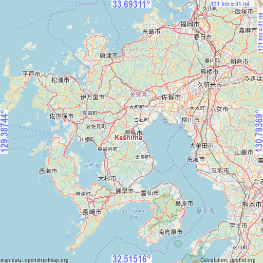
Kashima GPS coordinates[2]
33° 6' 21.996" North, 130° 5' 26.016" East
| Map corner | latitude | longitude |
|---|---|---|
| Upper-left | 33.69311°, | 129.38744° |
| Center: | 33.10611°, | 130.09056° |
| Lower-right: | 32.51516°, | 130.79369° |
| Map W x H: | 131×131 km | = 81.4×81.4mi |
| max Lat: | 45.40944° ⇑90.2% North |
| Kashima: | 33.10611° |
| min Lat: | ⇓9.8% South 24.34478° |
| min Long | Kashima | max Long |
| 123° | 130.09056° | 145.575° |
| W 3.7%⇐ | ⇒96.3% E |
Elevation
Elevation of Kashima is 20 m = 66 ft, and this is 64.6 m = 212 ft below average elevation for this country.
| Max E: |
1086 m = 3563 ft | 59.1% |
| Avg. | 84.6 m = 278 ft | |
| Kashima | 20 m = 66 ft | |
Min E: |
-2 m = -7 ft | 40.9% |
See also: Japan elevation on elevation.city.
Geographical zone
Kashima is located in North temperate zone (between Tropic of Cancer and the Arctic Circle). Distance of this Northern Tropic circle is 1075.1 km =668 mi to South.| Distance of | km | miles | from Kashima |
|---|---|---|---|
| North Pole | 6326 | 3930.8 | to North |
| Arctic Circle | 3720.1 | 2311.6 | to North |
| Tropic Cancer | 1075.1 | 668 | to South |
| Equator | 3681.1 | 2287.3 | to South |


Nearby cities:
15 places around Kashima: (largest is in red/bold)
• Imari
27.7 km =17.2 mi,  317°
317°
• Imarichō-kō
27.1 km =16.8 mi,  313°
313°
• Isahaya
29.8 km =18.5 mi,  188°
188°
• Kanzaki
33.6 km =20.9 mi,  43°
43°
• Ogi
21.7 km =13.5 mi,  26°
26°
• Saga
24.1 km =15 mi,  54°
54°
• Takeo
12 km =7.5 mi, 322°
• Takeochō-takeo
11.4 km =7.1 mi,  325°
325°
• Taku
19.1 km =11.9 mi,  5°
5°
• Ureshino
4.5 km =2.8 mi, 316°
• Ureshinomachi-shimojuku
8.2 km =5.1 mi,  275°
275°
• Yanagawa
29.6 km =18.4 mi,  76°
76°
• Ōkawa
28.7 km =17.8 mi,  67°
67°
• Ōmura
24.2 km =15 mi,  211°
211°
• Ōmuta
34.5 km =21.4 mi,  103°
103°
Sources, notices
• [Note1] Compared only with cities in Japan existing in our database
• [Src1] Map data: © OpenStreetMap contributors (CC-BY-SA)
• [Src2] Other city data from geonames.org with taken over terms of usage.
• [Src3] Geographical zone / Annual Mean Temperature by Robert A. Rohde @ Wikipedia
