Saga geodata
Saga is a seat of a first-order administrative division; located in Japan in Asia/Tokyo (GMT+9) time zone. With population of 165,236 people, there are 125 cities with bigger population in this country. Compared to other cities in Japan, 88.8% of cities are located further ↑North; 95.1% of cities are located further →East and 93.5% of cities have higher elevation than Saga. Note1


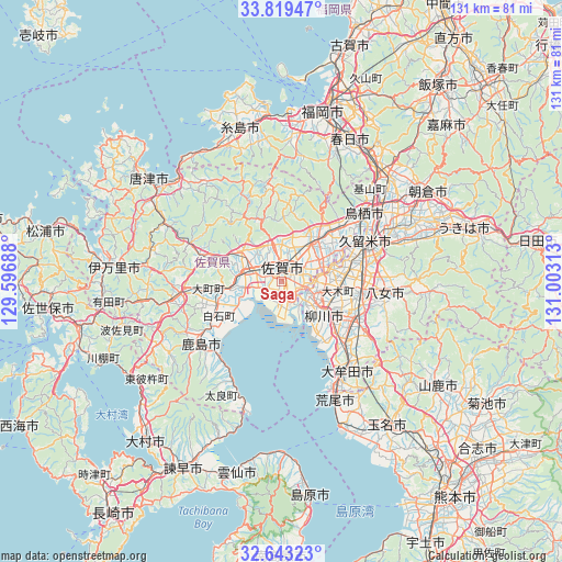
Saga GPS coordinates[2]
33° 13' 59.988" North, 130° 18' 0" East
| Map corner | latitude | longitude |
|---|---|---|
| Upper-left | 33.81947°, | 129.59688° |
| Center: | 33.23333°, | 130.3° |
| Lower-right: | 32.64323°, | 131.00313° |
| Map W x H: | 130.8×130.8 km | = 81.3×81.3mi |
| max Lat: | 45.40944° ⇑88.8% North |
| Saga: | 33.23333° |
| min Lat: | ⇓11.2% South 24.34478° |
| min Long | Saga | max Long |
| 123° | 130.3° | 145.575° |
| W 4.9%⇐ | ⇒95.1% E |
Elevation
Elevation of Saga is 4 m = 13 ft, and this is 80.6 m = 264 ft below average elevation for this country.
| Max E: |
1086 m = 3563 ft | 93.5% |
| Avg. | 84.6 m = 278 ft | |
| Saga | 4 m = 13 ft | |
Min E: |
-2 m = -7 ft | 6.5% |
See also: Saga elevation on elevation.city.
Geographical zone
Saga is located in North temperate zone (between Tropic of Cancer and the Arctic Circle). Distance of this Northern Tropic circle is 1089.3 km =676.9 mi to South.| Distance of | km | miles | from Saga |
|---|---|---|---|
| North Pole | 6311.9 | 3922 | to North |
| Arctic Circle | 3706 | 2302.8 | to North |
| Tropic Cancer | 1089.3 | 676.9 | to South |
| Equator | 3695.2 | 2296.1 | to South |


Nearby cities:
15 places around Saga: (largest is in red/bold)
• Chikugo
18.1 km =11.2 mi,  99°
99°
• Kanzaki
10.8 km =6.7 mi,  20°
20°
• Kanzakimachi-kanzaki
10.9 km =6.8 mi,  39°
39°
• Kashima
24.1 km =15 mi,  234°
234°
• Kurume
22.2 km =13.8 mi,  65°
65°
• Miyama
22.4 km =13.9 mi,  123°
123°
• Ogi
11.1 km =6.9 mi,  298°
298°
• Setakamachi-takayanagi
18.1 km =11.2 mi, 121°
• Takeochō-takeo
26.4 km =16.4 mi,  259°
259°
• Taku
18.4 km =11.4 mi,  285°
285°
• Tosu
25 km =15.5 mi,  53°
53°
• Ureshino
25.1 km =15.6 mi,  244°
244°
• Yanagawa
11.9 km =7.4 mi,  128°
128°
• Ōkawa
7.6 km =4.7 mi,  113°
113°
• Ōmuta
26.3 km =16.3 mi,  147°
147°
Sources, notices
• [Note1] Compared only with cities in Japan existing in our database
• [Src1] Map data: © OpenStreetMap contributors (CC-BY-SA)
• [Src2] Other city data from geonames.org with taken over terms of usage.
• [Src3] Geographical zone / Annual Mean Temperature by Robert A. Rohde @ Wikipedia
