Hekinan geodata
Hekinan (Aichi) is a seat of a second-order administrative division; located in Japan in Asia/Tokyo (GMT+9) time zone. With population of 68,872 people, there are 281 cities with bigger population in this country. Compared to other cities in Japan, 61.7% of cities are located further ↑North; 52.1% of cities are located further →East and 95.3% of cities have higher elevation than Hekinan. Note1


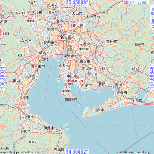
Hekinan GPS coordinates[2]
34° 52' 59.988" North, 136° 58' 59.988" East
| Map corner | latitude | longitude |
|---|---|---|
| Upper-left | 35.45809°, | 136.28021° |
| Center: | 34.88333°, | 136.98333° |
| Lower-right: | 34.30452°, | 137.68646° |
| Map W x H: | 128.3×128.3 km | = 79.7×79.7mi |
| max Lat: | 45.40944° ⇑61.7% North |
| Hekinan: | 34.88333° |
| min Lat: | ⇓38.3% South 24.34478° |
| min Long | Hekinan | max Long |
| 123° | 136.98333° | 145.575° |
| W 47.9%⇐ | ⇒52.1% E |
Elevation
Elevation of Hekinan is 3 m = 10 ft, and this is 81.6 m = 268 ft below average elevation for this country.
| Max E: |
1086 m = 3563 ft | 95.3% |
| Avg. | 84.6 m = 278 ft | |
| Hekinan | 3 m = 10 ft | |
Min E: |
-2 m = -7 ft | 4.7% |
See also: Hekinan elevation on elevation.city.
Geographical zone
Hekinan is located in North temperate zone (between Tropic of Cancer and the Arctic Circle). Distance of this Northern Tropic circle is 1272.7 km =790.8 mi to South.| Distance of | km | miles | from Hekinan |
|---|---|---|---|
| North Pole | 6128.4 | 3808 | to North |
| Arctic Circle | 3522.5 | 2188.8 | to North |
| Tropic Cancer | 1272.7 | 790.8 | to South |
| Equator | 3878.7 | 2410.1 | to South |


Nearby cities:
15 places around Hekinan: (largest is in red/bold)
• Anjō
12.2 km =7.6 mi,  46°
46°
• Chiryū
13.7 km =8.5 mi,  19°
19°
• Chita
17.1 km =10.6 mi,  320°
320°
• Handa
4.6 km =2.9 mi,  270°
270°
• Ishiki
9.8 km =6.1 mi,  161°
161°
• Kariya
11.1 km =6.9 mi,  0°
0°
• Nishio
6.4 km =4 mi,  106°
106°
• Okazaki
18.3 km =11.4 mi,  66°
66°
• Takahama
3.7 km =2.3 mi, 0°
• Taketoyo
7.1 km =4.4 mi,  238°
238°
• Tokoname
12.2 km =7.6 mi, 270°
• Toyoake
17.3 km =10.7 mi, 4°
• Toyohama
19.9 km =12.4 mi,  193°
193°
• Tōkai
16.9 km =10.5 mi,  336°
336°
• Ōbu
15.2 km =9.4 mi,  348°
348°
Sources, notices
• [Note1] Compared only with cities in Japan existing in our database
• [Src1] Map data: © OpenStreetMap contributors (CC-BY-SA)
• [Src2] Other city data from geonames.org with taken over terms of usage.
• [Src3] Geographical zone / Annual Mean Temperature by Robert A. Rohde @ Wikipedia
