Toyoake geodata
Toyoake (Aichi) is a seat of a second-order administrative division; located in Japan in Asia/Tokyo (GMT+9) time zone. In our database, there are 767 cities with bigger population. Compared to other cities in Japan, 57.4% of cities are located further ↑North; 51.7% of cities are located further →East and 68.3% of cities have higher elevation than Toyoake. Note1


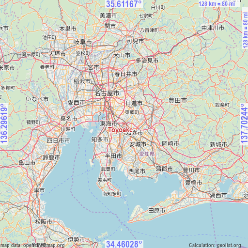
Toyoake GPS coordinates[2]
35° 2' 16.8" North, 136° 59' 57.516" East
| Map corner | latitude | longitude |
|---|---|---|
| Upper-left | 35.61167°, | 136.29619° |
| Center: | 35.038°, | 136.99931° |
| Lower-right: | 34.46028°, | 137.70244° |
| Map W x H: | 128×128 km | = 79.5×79.5mi |
| max Lat: | 45.40944° ⇑57.4% North |
| Toyoake: | 35.038° |
| min Lat: | ⇓42.6% South 24.34478° |
| min Long | Toyoake | max Long |
| 123° | 136.99931° | 145.575° |
| W 48.3%⇐ | ⇒51.7% E |
Elevation
Elevation of Toyoake is 13 m = 43 ft, and this is 71.6 m = 235 ft below average elevation for this country.
| Max E: |
1086 m = 3563 ft | 68.3% |
| Avg. | 84.6 m = 278 ft | |
| Toyoake | 13 m = 43 ft | |
Min E: |
-2 m = -7 ft | 31.7% |
See also: Japan elevation on elevation.city.
Geographical zone
Toyoake is located in North temperate zone (between Tropic of Cancer and the Arctic Circle). Distance of this Northern Tropic circle is 1289.9 km =801.5 mi to South.| Distance of | km | miles | from Toyoake |
|---|---|---|---|
| North Pole | 6111.2 | 3797.3 | to North |
| Arctic Circle | 3505.3 | 2178.1 | to North |
| Tropic Cancer | 1289.9 | 801.5 | to South |
| Equator | 3895.9 | 2420.8 | to South |


Nearby cities:
15 places around Toyoake: (largest is in red/bold)
• Anjō
11.5 km =7.1 mi,  140°
140°
• Chiryū
5.2 km =3.2 mi, 143°
• Chita
12.9 km =8 mi,  252°
252°
• Handa
18.2 km =11.3 mi,  199°
199°
• Hekinan
17.3 km =10.7 mi,  184°
184°
• Kariya
6.3 km =3.9 mi,  193°
193°
• Miyoshi
10.1 km =6.3 mi,  55°
55°
• Nagakute
15.9 km =9.9 mi,  19°
19°
• Nagoya
18.1 km =11.2 mi,  332°
332°
• Nisshin
12 km =7.5 mi, 23°
• Okazaki
18.1 km =11.2 mi,  122°
122°
• Takahama
13.6 km =8.5 mi, 186°
• Toyota
14.6 km =9.1 mi,  69°
69°
• Tōkai
8.4 km =5.2 mi,  258°
258°
• Ōbu
5.1 km =3.2 mi,  243°
243°
Sources, notices
• [Note1] Compared only with cities in Japan existing in our database
• [Src1] Map data: © OpenStreetMap contributors (CC-BY-SA)
• [Src2] Other city data from geonames.org with taken over terms of usage.
• [Src3] Geographical zone / Annual Mean Temperature by Robert A. Rohde @ Wikipedia
