Hachiōji geodata
Hachiōji (Tokyo) is a seat of a second-order administrative division; located in Japan in Asia/Tokyo (GMT+9) time zone. With population of 579,399 people, there are 20 cities with bigger population in this country. Compared to other cities in Japan, 56.7% of cities are located further ↓South; 64.9% of cities are located further ←West and 80.9% of cities have lower elevation than Hachiōji. Note1


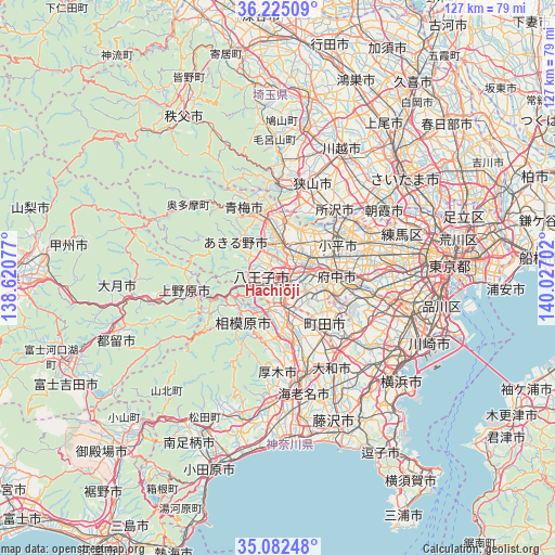
Hachiōji GPS coordinates[2]
35° 39' 20.988" North, 139° 19' 26.004" East
| Map corner | latitude | longitude |
|---|---|---|
| Upper-left | 36.22509°, | 138.62077° |
| Center: | 35.65583°, | 139.32389° |
| Lower-right: | 35.08248°, | 140.02702° |
| Map W x H: | 127×127 km | = 78.9×78.9mi |
| max Lat: | 45.40944° ⇑43.3% North |
| Hachiōji: | 35.65583° |
| min Lat: | ⇓56.7% South 24.34478° |
| min Long | Hachiōji | max Long |
| 123° | 139.32389° | 145.575° |
| W 64.9%⇐ | ⇒35.1% E |
Elevation
Elevation of Hachiōji is 127 m = 417 ft, and this is 42.4 m = 139 ft above average elevation for this country.
| Max E: |
1086 m = 3563 ft | 19.1% |
| Hachiōji | 127 m 417 ft | |
| Avg. | 84.6 m = 278 ft | |
Min E: |
-2 m = -7 ft | 80.9% |
See also: Hachiōji elevation on elevation.city.
Geographical zone
Hachiōji is located in North temperate zone (between Tropic of Cancer and the Arctic Circle). Distance of this Northern Tropic circle is 1358.6 km =844.2 mi to South.| Distance of | km | miles | from Hachiōji |
|---|---|---|---|
| North Pole | 6042.5 | 3754.6 | to North |
| Arctic Circle | 3436.6 | 2135.4 | to North |
| Tropic Cancer | 1358.6 | 844.2 | to South |
| Equator | 3964.6 | 2463.5 | to South |


Nearby cities:
15 places around Hachiōji: (largest is in red/bold)
• Akiruno
11.6 km =7.2 mi,  314°
314°
• Akishima
8.8 km =5.5 mi,  35°
35°
• Fuchū
14.4 km =8.9 mi,  81°
81°
• Fussa
9 km =5.6 mi,  359°
359°
• Hamura
11.8 km =7.3 mi, 358°
• Higashiyamato
14.2 km =8.8 mi, 42°
• Hino
7.2 km =4.5 mi,  74°
74°
• Itsukaichi
12.3 km =7.6 mi, 308°
• Kokubunji
14.6 km =9.1 mi, 69°
• Kunitachi
10.8 km =6.7 mi, 73°
• Musashimurayama
13.4 km =8.3 mi, 43°
• Sagamihara
12.4 km =7.7 mi,  216°
216°
• Tachikawa
10.4 km =6.5 mi,  55°
55°
• Tama
13.1 km =8.1 mi,  95°
95°
• Ōme
16 km =9.9 mi,  332°
332°
Sources, notices
• [Note1] Compared only with cities in Japan existing in our database
• [Src1] Map data: © OpenStreetMap contributors (CC-BY-SA)
• [Src2] Other city data from geonames.org with taken over terms of usage.
• [Src3] Geographical zone / Annual Mean Temperature by Robert A. Rohde @ Wikipedia
