Itsukaichi geodata
Itsukaichi (Tokyo) is a populated place; located in Japan in Asia/Tokyo (GMT+9) time zone. With population of 24,954 people, there are 614 cities with bigger population in this country. Compared to other cities in Japan, 59.5% of cities are located further ↓South; 63% of cities are located further ←West and 86.5% of cities have lower elevation than Itsukaichi. Note1


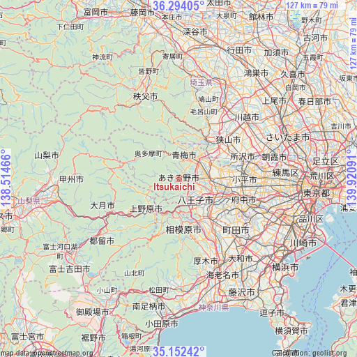
Itsukaichi GPS coordinates[2]
35° 43' 31.008" North, 139° 13' 4.008" East
| Map corner | latitude | longitude |
|---|---|---|
| Upper-left | 36.29405°, | 138.51466° |
| Center: | 35.72528°, | 139.21778° |
| Lower-right: | 35.15242°, | 139.92091° |
| Map W x H: | 126.9×126.9 km | = 78.9×78.9mi |
| max Lat: | 45.40944° ⇑40.5% North |
| Itsukaichi: | 35.72528° |
| min Lat: | ⇓59.5% South 24.34478° |
| min Long | Itsukaichi | max Long |
| 123° | 139.21778° | 145.575° |
| W 63%⇐ | ⇒37% E |
Elevation
Elevation of Itsukaichi is 184 m = 604 ft, and this is 99.4 m = 326 ft above average elevation for this country.
| Max E: |
1086 m = 3563 ft | 13.5% |
| Itsukaichi | 184 m 604 ft | |
| Avg. | 84.6 m = 278 ft | |
Min E: |
-2 m = -7 ft | 86.5% |
See also: Japan elevation on elevation.city.
Geographical zone
Itsukaichi is located in North temperate zone (between Tropic of Cancer and the Arctic Circle). Distance of this Northern Tropic circle is 1366.4 km =849 mi to South.| Distance of | km | miles | from Itsukaichi |
|---|---|---|---|
| North Pole | 6034.8 | 3749.8 | to North |
| Arctic Circle | 3428.9 | 2130.6 | to North |
| Tropic Cancer | 1366.4 | 849 | to South |
| Equator | 3972.3 | 2468.3 | to South |


Nearby cities:
15 places around Itsukaichi: (largest is in red/bold)
• Akiruno
1.3 km =0.8 mi,  74°
74°
• Akishima
14.7 km =9.1 mi,  91°
91°
• Fussa
9.6 km =6 mi,  82°
82°
• Hachiōji
12.3 km =7.6 mi,  128°
128°
• Hamura
10.1 km =6.3 mi, 65°
• Hannō
16.7 km =10.4 mi,  32°
32°
• Higashiyamato
19.3 km =12 mi, 81°
• Hino
17.5 km =10.9 mi,  109°
109°
• Iruma
17 km =10.6 mi,  52°
52°
• Kunitachi
20.5 km =12.7 mi,  103°
103°
• Musashimurayama
18.9 km =11.7 mi, 84°
• Sagamihara
17.7 km =11 mi,  173°
173°
• Tachikawa
18.2 km =11.3 mi, 95°
• Uenohara
15.1 km =9.4 mi,  217°
217°
• Ōme
6.9 km =4.3 mi,  19°
19°
Sources, notices
• [Note1] Compared only with cities in Japan existing in our database
• [Src1] Map data: © OpenStreetMap contributors (CC-BY-SA)
• [Src2] Other city data from geonames.org with taken over terms of usage.
• [Src3] Geographical zone / Annual Mean Temperature by Robert A. Rohde @ Wikipedia
