Chigasaki geodata
Chigasaki (Kanagawa) is a seat of a second-order administrative division; located in Japan in Asia/Tokyo (GMT+9) time zone. With population of 231,657 people, there are 90 cities with bigger population in this country. Compared to other cities in Japan, 50.8% of cities are located further ↑North; 66.5% of cities are located further ←West and 86% of cities have higher elevation than Chigasaki. Note1


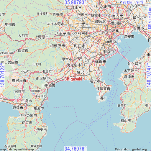
Chigasaki GPS coordinates[2]
35° 20' 10.968" North, 139° 24' 15.624" East
| Map corner | latitude | longitude |
|---|---|---|
| Upper-left | 35.90793°, | 138.70122° |
| Center: | 35.33638°, | 139.40434° |
| Lower-right: | 34.76076°, | 140.10747° |
| Map W x H: | 127.6×127.6 km | = 79.3×79.3mi |
| max Lat: | 45.40944° ⇑50.8% North |
| Chigasaki: | 35.33638° |
| min Lat: | ⇓49.2% South 24.34478° |
| min Long | Chigasaki | max Long |
| 123° | 139.40434° | 145.575° |
| W 66.5%⇐ | ⇒33.5% E |
Elevation
Elevation of Chigasaki is 6 m = 20 ft, and this is 78.6 m = 258 ft below average elevation for this country.
| Max E: |
1086 m = 3563 ft | 86% |
| Avg. | 84.6 m = 278 ft | |
| Chigasaki | 6 m = 20 ft | |
Min E: |
-2 m = -7 ft | 14% |
See also: Chigasaki elevation on elevation.city.
Geographical zone
Chigasaki is located in North temperate zone (between Tropic of Cancer and the Arctic Circle). Distance of this Northern Tropic circle is 1323.1 km =822.1 mi to South.| Distance of | km | miles | from Chigasaki |
|---|---|---|---|
| North Pole | 6078 | 3776.7 | to North |
| Arctic Circle | 3472.1 | 2157.5 | to North |
| Tropic Cancer | 1323.1 | 822.1 | to South |
| Equator | 3929 | 2441.4 | to South |


Nearby cities:
15 places around Chigasaki: (largest is in red/bold)
• Atsugi
12.2 km =7.6 mi,  344°
344°
• Ayase
11.2 km =7 mi,  9°
9°
• Ebina
10.9 km =6.8 mi,  355°
355°
• Fujisawa
6.7 km =4.2 mi,  77°
77°
• Hadano
16.8 km =10.4 mi,  283°
283°
• Hayama
17.1 km =10.6 mi,  112°
112°
• Hiratsuka
6.2 km =3.9 mi,  261°
261°
• Isehara
11 km =6.8 mi,  309°
309°
• Kamakura
13.6 km =8.5 mi,  102°
102°
• Minamirinkan
18 km =11.2 mi, 11°
• Ninomiya
14 km =8.7 mi,  253°
253°
• Yamato
15.7 km =9.8 mi,  15°
15°
• Zama
16.9 km =10.5 mi, 355°
• Zushi
16.4 km =10.2 mi, 106°
• Ōiso
8.3 km =5.2 mi, 253°
Sources, notices
• [Note1] Compared only with cities in Japan existing in our database
• [Src1] Map data: © OpenStreetMap contributors (CC-BY-SA)
• [Src2] Other city data from geonames.org with taken over terms of usage.
• [Src3] Geographical zone / Annual Mean Temperature by Robert A. Rohde @ Wikipedia
