Atsugi geodata
Atsugi (Kanagawa) is a seat of a second-order administrative division; located in Japan in Asia/Tokyo (GMT+9) time zone. With population of 229,199 people, there are 92 cities with bigger population in this country. Compared to other cities in Japan, 52.3% of cities are located further ↓South; 65.6% of cities are located further ←West and 52.3% of cities have higher elevation than Atsugi. Note1


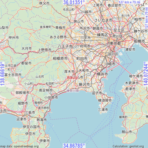
Atsugi GPS coordinates[2]
35° 26' 33.792" North, 139° 22' 9.516" East
| Map corner | latitude | longitude |
|---|---|---|
| Upper-left | 36.01351°, | 138.66619° |
| Center: | 35.44272°, | 139.36931° |
| Lower-right: | 34.86785°, | 140.07244° |
| Map W x H: | 127.4×127.4 km | = 79.2×79.2mi |
| max Lat: | 45.40944° ⇑47.7% North |
| Atsugi: | 35.44272° |
| min Lat: | ⇓52.3% South 24.34478° |
| min Long | Atsugi | max Long |
| 123° | 139.36931° | 145.575° |
| W 65.6%⇐ | ⇒34.4% E |
Elevation
Elevation of Atsugi is 26 m = 85 ft, and this is 58.6 m = 192 ft below average elevation for this country.
| Max E: |
1086 m = 3563 ft | 52.3% |
| Avg. | 84.6 m = 278 ft | |
| Atsugi | 26 m = 85 ft | |
Min E: |
-2 m = -7 ft | 47.7% |
See also: Atsugi elevation on elevation.city.
Geographical zone
Atsugi is located in North temperate zone (between Tropic of Cancer and the Arctic Circle). Distance of this Northern Tropic circle is 1334.9 km =829.5 mi to South.| Distance of | km | miles | from Atsugi |
|---|---|---|---|
| North Pole | 6066.2 | 3769.4 | to North |
| Arctic Circle | 3460.3 | 2150.1 | to North |
| Tropic Cancer | 1334.9 | 829.5 | to South |
| Equator | 3940.9 | 2448.8 | to South |


Nearby cities:
15 places around Atsugi: (largest is in red/bold)
• Ayase
5.2 km =3.2 mi,  99°
99°
• Chigasaki
12.2 km =7.6 mi,  164°
164°
• Ebina
2.4 km =1.5 mi,  112°
112°
• Fujisawa
14.2 km =8.8 mi,  136°
136°
• Hadano
15.4 km =9.6 mi,  238°
238°
• Hiratsuka
13.1 km =8.1 mi,  192°
192°
• Isehara
7.2 km =4.5 mi,  227°
227°
• Kamakura
22.1 km =13.7 mi,  132°
132°
• Machida
13.1 km =8.1 mi,  34°
34°
• Minamirinkan
8.9 km =5.5 mi,  48°
48°
• Ninomiya
18.8 km =11.7 mi,  213°
213°
• Sagamihara
18 km =11.2 mi,  320°
320°
• Yamato
8.1 km =5 mi,  65°
65°
• Zama
5.4 km =3.4 mi,  21°
21°
• Ōiso
14.9 km =9.3 mi,  198°
198°
Sources, notices
• [Note1] Compared only with cities in Japan existing in our database
• [Src1] Map data: © OpenStreetMap contributors (CC-BY-SA)
• [Src2] Other city data from geonames.org with taken over terms of usage.
• [Src3] Geographical zone / Annual Mean Temperature by Robert A. Rohde @ Wikipedia
