Zama geodata
Zama (Kanagawa) is a seat of a second-order administrative division; located in Japan in Asia/Tokyo (GMT+9) time zone. With population of 134,671 people, there are 150 cities with bigger population in this country. Compared to other cities in Japan, 53.2% of cities are located further ↓South; 66.1% of cities are located further ←West and 53.2% of cities have lower elevation than Zama. Note1


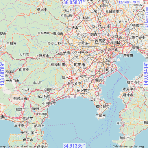
Zama GPS coordinates[2]
35° 29' 16.44" North, 139° 23' 27.636" East
| Map corner | latitude | longitude |
|---|---|---|
| Upper-left | 36.05837°, | 138.68789° |
| Center: | 35.4879°, | 139.39101° |
| Lower-right: | 34.91335°, | 140.09414° |
| Map W x H: | 127.3×127.3 km | = 79.1×79.1mi |
| max Lat: | 45.40944° ⇑46.8% North |
| Zama: | 35.4879° |
| min Lat: | ⇓53.2% South 24.34478° |
| min Long | Zama | max Long |
| 123° | 139.39101° | 145.575° |
| W 66.1%⇐ | ⇒33.9% E |
Elevation
Elevation of Zama is 32 m = 105 ft, and this is 52.6 m = 173 ft below average elevation for this country.
| Max E: |
1086 m = 3563 ft | 46.8% |
| Avg. | 84.6 m = 278 ft | |
| Zama | 32 m = 105 ft | |
Min E: |
-2 m = -7 ft | 53.2% |
See also: Zama elevation on elevation.city.
Geographical zone
Zama is located in North temperate zone (between Tropic of Cancer and the Arctic Circle). Distance of this Northern Tropic circle is 1340 km =832.6 mi to South.| Distance of | km | miles | from Zama |
|---|---|---|---|
| North Pole | 6061.2 | 3766.3 | to North |
| Arctic Circle | 3455.3 | 2147 | to North |
| Tropic Cancer | 1340 | 832.6 | to South |
| Equator | 3945.9 | 2451.9 | to South |


Nearby cities:
15 places around Zama: (largest is in red/bold)
• Atsugi
5.4 km =3.4 mi,  201°
201°
• Ayase
6.6 km =4.1 mi,  151°
151°
• Chigasaki
16.9 km =10.5 mi,  175°
175°
• Ebina
6 km =3.7 mi, 177°
• Fujisawa
17.3 km =10.7 mi, 153°
• Hachiōji
19.6 km =12.2 mi,  341°
341°
• Hadano
20 km =12.4 mi,  229°
229°
• Hiratsuka
18.4 km =11.4 mi, 195°
• Inagi
18.9 km =11.7 mi,  31°
31°
• Isehara
12.3 km =7.6 mi,  216°
216°
• Machida
8 km =5 mi,  42°
42°
• Minamirinkan
4.8 km =3 mi,  80°
80°
• Sagamihara
16.1 km =10 mi,  303°
303°
• Tama
18.7 km =11.6 mi,  22°
22°
• Yamato
5.7 km =3.5 mi,  107°
107°
Sources, notices
• [Note1] Compared only with cities in Japan existing in our database
• [Src1] Map data: © OpenStreetMap contributors (CC-BY-SA)
• [Src2] Other city data from geonames.org with taken over terms of usage.
• [Src3] Geographical zone / Annual Mean Temperature by Robert A. Rohde @ Wikipedia
