Ninomiya geodata
Ninomiya (Kanagawa) is a populated place; located in Japan in Asia/Tokyo (GMT+9) time zone. With population of 31,412 people, there are 533 cities with bigger population in this country. Compared to other cities in Japan, 51.9% of cities are located further ↑North; 63.8% of cities are located further ←West and 54% of cities have higher elevation than Ninomiya. Note1


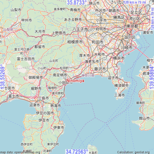
Ninomiya GPS coordinates[2]
35° 18' 5.4" North, 139° 15' 20.916" East
| Map corner | latitude | longitude |
|---|---|---|
| Upper-left | 35.8733°, | 138.55269° |
| Center: | 35.3015°, | 139.25581° |
| Lower-right: | 34.72563°, | 139.95894° |
| Map W x H: | 127.6×127.6 km | = 79.3×79.3mi |
| max Lat: | 45.40944° ⇑51.9% North |
| Ninomiya: | 35.3015° |
| min Lat: | ⇓48.1% South 24.34478° |
| min Long | Ninomiya | max Long |
| 123° | 139.25581° | 145.575° |
| W 63.8%⇐ | ⇒36.2% E |
Elevation
Elevation of Ninomiya is 24 m = 79 ft, and this is 60.6 m = 199 ft below average elevation for this country.
| Max E: |
1086 m = 3563 ft | 54% |
| Avg. | 84.6 m = 278 ft | |
| Ninomiya | 24 m = 79 ft | |
Min E: |
-2 m = -7 ft | 46% |
See also: Japan elevation on elevation.city.
Geographical zone
Ninomiya is located in North temperate zone (between Tropic of Cancer and the Arctic Circle). Distance of this Northern Tropic circle is 1319.2 km =819.7 mi to South.| Distance of | km | miles | from Ninomiya |
|---|---|---|---|
| North Pole | 6081.9 | 3779.1 | to North |
| Arctic Circle | 3476 | 2159.9 | to North |
| Tropic Cancer | 1319.2 | 819.7 | to South |
| Equator | 3925.2 | 2439 | to South |


Nearby cities:
15 places around Ninomiya: (largest is in red/bold)
• Atsugi
18.8 km =11.7 mi,  33°
33°
• Ayase
21.4 km =13.3 mi,  46°
46°
• Chigasaki
14 km =8.7 mi,  73°
73°
• Ebina
19.4 km =12.1 mi,  40°
40°
• Fujisawa
20.7 km =12.9 mi,  75°
75°
• Hadano
8.3 km =5.2 mi,  339°
339°
• Hakone
24.3 km =15.1 mi,  239°
239°
• Hiratsuka
8 km =5 mi, 68°
• Isehara
11.9 km =7.4 mi,  24°
24°
• Minamiashigara
13.4 km =8.3 mi,  278°
278°
• Odawara
10.1 km =6.3 mi, 239°
• Yamakita
17.4 km =10.8 mi,  293°
293°
• Yugawara
24.1 km =15 mi,  225°
225°
• Zama
24.1 km =15 mi, 30°
• Ōiso
5.7 km =3.5 mi, 74°
Sources, notices
• [Note1] Compared only with cities in Japan existing in our database
• [Src1] Map data: © OpenStreetMap contributors (CC-BY-SA)
• [Src2] Other city data from geonames.org with taken over terms of usage.
• [Src3] Geographical zone / Annual Mean Temperature by Robert A. Rohde @ Wikipedia
