Marumori geodata
Marumori (Miyagi) is a populated place; located in Japan in Asia/Tokyo (GMT+9) time zone. With population of 16,752 people, there are 728 cities with bigger population in this country. Compared to other cities in Japan, 86.7% of cities are located further ↓South; 90.7% of cities are located further ←West and 56.6% of cities have higher elevation than Marumori. Note1


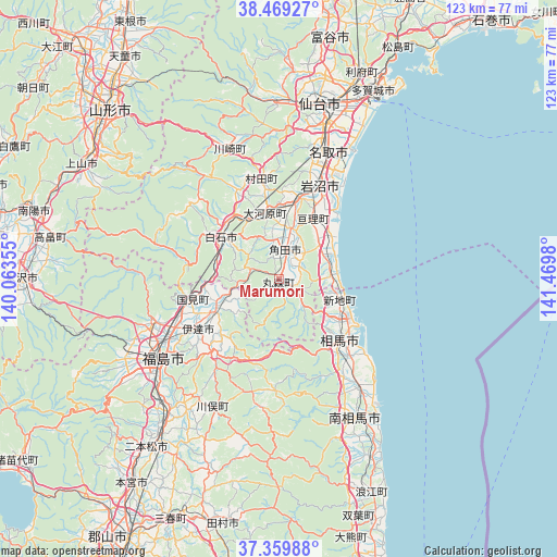
Marumori GPS coordinates[2]
37° 55' 0.012" North, 140° 46' 0.012" East
| Map corner | latitude | longitude |
|---|---|---|
| Upper-left | 38.46927°, | 140.06355° |
| Center: | 37.91667°, | 140.76667° |
| Lower-right: | 37.35988°, | 141.4698° |
| Map W x H: | 123.4×123.4 km | = 76.7×76.7mi |
| max Lat: | 45.40944° ⇑13.3% North |
| Marumori: | 37.91667° |
| min Lat: | ⇓86.7% South 24.34478° |
| min Long | Marumori | max Long |
| 123° | 140.76667° | 145.575° |
| W 90.7%⇐ | ⇒9.3% E |
Elevation
Elevation of Marumori is 22 m = 72 ft, and this is 62.6 m = 205 ft below average elevation for this country.
| Max E: |
1086 m = 3563 ft | 56.6% |
| Avg. | 84.6 m = 278 ft | |
| Marumori | 22 m = 72 ft | |
Min E: |
-2 m = -7 ft | 43.4% |
See also: Japan elevation on elevation.city.
Geographical zone
Marumori is located in North temperate zone (between Tropic of Cancer and the Arctic Circle). Distance of this Northern Tropic circle is 1610 km =1000.4 mi to South.| Distance of | km | miles | from Marumori |
|---|---|---|---|
| North Pole | 5791.1 | 3598.4 | to North |
| Arctic Circle | 3185.2 | 1979.2 | to North |
| Tropic Cancer | 1610 | 1000.4 | to South |
| Equator | 4215.9 | 2619.6 | to South |


Nearby cities:
15 places around Marumori: (largest is in red/bold)
• Date
25.9 km =16.1 mi,  244°
244°
• Fukushima
32.2 km =20 mi,  234°
234°
• Hobaramachi
22 km =13.7 mi, 239°
• Iwanuma
22.4 km =13.9 mi,  21°
21°
• Kakuda
6.4 km =4 mi,  4°
4°
• Minami-Sōma
37 km =23 mi,  149°
149°
• Natori-shi
29.6 km =18.4 mi, 20°
• Nihommatsu
47.3 km =29.4 mi,  218°
218°
• Sendai
39.9 km =24.8 mi,  12°
12°
• Shiroishi
16.2 km =10.1 mi,  306°
306°
• Sōma
19.8 km =12.3 mi,  133°
133°
• Tagajō-shi
47.3 km =29.4 mi,  25°
25°
• Watari
15.1 km =9.4 mi, 29°
• Yanagawamachi-saiwaichō
16.4 km =10.2 mi, 243°
• Ōkawara
15.1 km =9.4 mi,  348°
348°
Sources, notices
• [Note1] Compared only with cities in Japan existing in our database
• [Src1] Map data: © OpenStreetMap contributors (CC-BY-SA)
• [Src2] Other city data from geonames.org with taken over terms of usage.
• [Src3] Geographical zone / Annual Mean Temperature by Robert A. Rohde @ Wikipedia
