Iwanuma geodata
Iwanuma (Miyagi) is a seat of a second-order administrative division; located in Japan in Asia/Tokyo (GMT+9) time zone. With population of 42,411 people, there are 431 cities with bigger population in this country. Compared to other cities in Japan, 87.8% of cities are located further ↓South; 91.5% of cities are located further ←West and 89.6% of cities have higher elevation than Iwanuma. Note1


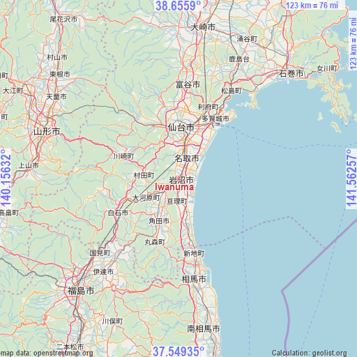
Iwanuma GPS coordinates[2]
38° 6' 16.992" North, 140° 51' 33.984" East
| Map corner | latitude | longitude |
|---|---|---|
| Upper-left | 38.6559°, | 140.15632° |
| Center: | 38.10472°, | 140.85944° |
| Lower-right: | 37.54935°, | 141.56257° |
| Map W x H: | 123×123 km | = 76.4×76.4mi |
| max Lat: | 45.40944° ⇑12.2% North |
| Iwanuma: | 38.10472° |
| min Lat: | ⇓87.8% South 24.34478° |
| min Long | Iwanuma | max Long |
| 123° | 140.85944° | 145.575° |
| W 91.5%⇐ | ⇒8.5% E |
Elevation
Elevation of Iwanuma is 5 m = 16 ft, and this is 79.6 m = 261 ft below average elevation for this country.
| Max E: |
1086 m = 3563 ft | 89.6% |
| Avg. | 84.6 m = 278 ft | |
| Iwanuma | 5 m = 16 ft | |
Min E: |
-2 m = -7 ft | 10.4% |
See also: Iwanuma elevation on elevation.city.
Geographical zone
Iwanuma is located in North temperate zone (between Tropic of Cancer and the Arctic Circle). Distance of this Northern Tropic circle is 1630.9 km =1013.4 mi to South.| Distance of | km | miles | from Iwanuma |
|---|---|---|---|
| North Pole | 5770.2 | 3585.4 | to North |
| Arctic Circle | 3164.3 | 1966.2 | to North |
| Tropic Cancer | 1630.9 | 1013.4 | to South |
| Equator | 4236.8 | 2632.6 | to South |


Nearby cities:
15 places around Iwanuma: (largest is in red/bold)
• Hobaramachi
42 km =26.1 mi,  220°
220°
• Kakuda
16.4 km =10.2 mi,  207°
207°
• Marumori
22.4 km =13.9 mi,  201°
201°
• Matsushima
34.7 km =21.6 mi,  30°
30°
• Natori-shi
7.2 km =4.5 mi,  16°
16°
• Rifu
27.2 km =16.9 mi, 22°
• Sendai
18 km =11.2 mi,  2°
2°
• Shiogama
28 km =17.4 mi, 32°
• Shiroishi
23.9 km =14.9 mi,  241°
241°
• Sōma
35.2 km =21.9 mi,  169°
169°
• Tagajō-shi
24.9 km =15.5 mi, 29°
• Tomiya
32.1 km =19.9 mi, 4°
• Watari
7.8 km =4.8 mi,  185°
185°
• Yanagawamachi-saiwaichō
36.3 km =22.6 mi, 218°
• Ōkawara
12.6 km =7.8 mi, 241°
Sources, notices
• [Note1] Compared only with cities in Japan existing in our database
• [Src1] Map data: © OpenStreetMap contributors (CC-BY-SA)
• [Src2] Other city data from geonames.org with taken over terms of usage.
• [Src3] Geographical zone / Annual Mean Temperature by Robert A. Rohde @ Wikipedia
