Ōkawara geodata
Ōkawara (Miyagi) is a populated place; located in Japan in Asia/Tokyo (GMT+9) time zone. With population of 23,340 people, there are 635 cities with bigger population in this country. Compared to other cities in Japan, 87.4% of cities are located further ↓South; 90.4% of cities are located further ←West and 59.1% of cities have higher elevation than Ōkawara. Note1


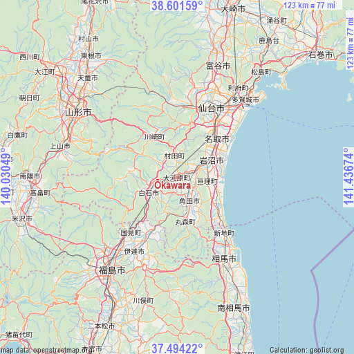
Ōkawara GPS coordinates[2]
38° 3' 0" North, 140° 44' 0.996" East
| Map corner | latitude | longitude |
|---|---|---|
| Upper-left | 38.60159°, | 140.03049° |
| Center: | 38.05°, | 140.73361° |
| Lower-right: | 37.49422°, | 141.43674° |
| Map W x H: | 123.1×123.1 km | = 76.5×76.5mi |
| max Lat: | 45.40944° ⇑12.6% North |
| Ōkawara: | 38.05° |
| min Lat: | ⇓87.4% South 24.34478° |
| min Long | Ōkawara | max Long |
| 123° | 140.73361° | 145.575° |
| W 90.4%⇐ | ⇒9.6% E |
Elevation
Elevation of Ōkawara is 20 m = 66 ft, and this is 64.6 m = 212 ft below average elevation for this country.
| Max E: |
1086 m = 3563 ft | 59.1% |
| Avg. | 84.6 m = 278 ft | |
| Ōkawara | 20 m = 66 ft | |
Min E: |
-2 m = -7 ft | 40.9% |
See also: Japan elevation on elevation.city.
Geographical zone
Ōkawara is located in North temperate zone (between Tropic of Cancer and the Arctic Circle). Distance of this Northern Tropic circle is 1624.8 km =1009.6 mi to South.| Distance of | km | miles | from Ōkawara |
|---|---|---|---|
| North Pole | 5776.3 | 3589.2 | to North |
| Arctic Circle | 3170.4 | 1970 | to North |
| Tropic Cancer | 1624.8 | 1009.6 | to South |
| Equator | 4230.8 | 2628.9 | to South |


Nearby cities:
15 places around Ōkawara: (largest is in red/bold)
• Date
33.1 km =20.6 mi,  218°
218°
• Hobaramachi
30.5 km =19 mi,  211°
211°
• Iwanuma
12.6 km =7.8 mi,  61°
61°
• Kakuda
9 km =5.6 mi,  158°
158°
• Marumori
15.1 km =9.4 mi,  168°
168°
• Natori-shi
18.4 km =11.4 mi,  45°
45°
• Rifu
37.8 km =23.5 mi,  34°
34°
• Sendai
26.8 km =16.7 mi, 25°
• Shiogama
39.6 km =24.6 mi,  41°
41°
• Shiroishi
11.4 km =7.1 mi,  242°
242°
• Sōma
33.4 km =20.8 mi,  149°
149°
• Tagajō-shi
36.3 km =22.6 mi, 39°
• Watari
10.4 km =6.5 mi,  99°
99°
• Yamagata
38 km =23.6 mi,  302°
302°
• Yanagawamachi-saiwaichō
25.1 km =15.6 mi, 207°
Sources, notices
• [Note1] Compared only with cities in Japan existing in our database
• [Src1] Map data: © OpenStreetMap contributors (CC-BY-SA)
• [Src2] Other city data from geonames.org with taken over terms of usage.
• [Src3] Geographical zone / Annual Mean Temperature by Robert A. Rohde @ Wikipedia
