Inawashiro geodata
Inawashiro (Fukushima) is a populated place; located in Japan in Asia/Tokyo (GMT+9) time zone. With population of 17,413 people, there are 726 cities with bigger population in this country. Compared to other cities in Japan, 84.6% of cities are located further ↓South; 80.7% of cities are located further ←West and 97.1% of cities have lower elevation than Inawashiro. Note1


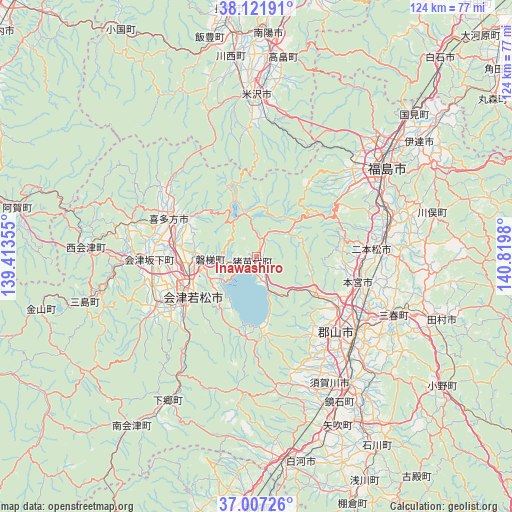
Inawashiro GPS coordinates[2]
37° 34' 0.012" North, 140° 7' 0.012" East
| Map corner | latitude | longitude |
|---|---|---|
| Upper-left | 38.12191°, | 139.41355° |
| Center: | 37.56667°, | 140.11667° |
| Lower-right: | 37.00726°, | 140.8198° |
| Map W x H: | 123.9×123.9 km | = 77×77mi |
| max Lat: | 45.40944° ⇑15.4% North |
| Inawashiro: | 37.56667° |
| min Lat: | ⇓84.6% South 24.34478° |
| min Long | Inawashiro | max Long |
| 123° | 140.11667° | 145.575° |
| W 80.7%⇐ | ⇒19.3% E |
Elevation
Elevation of Inawashiro is 532 m = 1745 ft, and this is 447.4 m = 1468 ft above average elevation for this country.
| Max E: |
1086 m = 3563 ft | 2.9% |
| Inawashiro | 532 m 1745 ft | |
| Avg. | 84.6 m = 278 ft | |
Min E: |
-2 m = -7 ft | 97.1% |
See also: Japan elevation on elevation.city.
Geographical zone
Inawashiro is located in North temperate zone (between Tropic of Cancer and the Arctic Circle). Distance of this Northern Tropic circle is 1571.1 km =976.2 mi to South.| Distance of | km | miles | from Inawashiro |
|---|---|---|---|
| North Pole | 5830 | 3622.6 | to North |
| Arctic Circle | 3224.2 | 2003.4 | to North |
| Tropic Cancer | 1571.1 | 976.2 | to South |
| Equator | 4177 | 2595.5 | to South |


Nearby cities:
15 places around Inawashiro: (largest is in red/bold)
• Aizu-Wakamatsu
17.3 km =10.7 mi,  241°
241°
• Date
43.7 km =27.2 mi,  50°
50°
• Fukushima
36.9 km =22.9 mi,  56°
56°
• Funehikimachi-funehiki
42.7 km =26.5 mi,  108°
108°
• Hobaramachi
47.2 km =29.3 mi, 53°
• Kitakata
23.9 km =14.9 mi,  292°
292°
• Kōriyama
29.9 km =18.6 mi,  128°
128°
• Miharu
35.6 km =22.1 mi, 114°
• Motomiya
25.7 km =16 mi,  103°
103°
• Nihommatsu
28 km =17.4 mi,  86°
86°
• Shirakawa
51.4 km =31.9 mi,  165°
165°
• Sukagawa
39.3 km =24.4 mi,  143°
143°
• Takahata
48.9 km =30.4 mi,  7°
7°
• Tamura
45.5 km =28.3 mi, 109°
• Yonezawa
38.2 km =23.7 mi,  0°
0°
Sources, notices
• [Note1] Compared only with cities in Japan existing in our database
• [Src1] Map data: © OpenStreetMap contributors (CC-BY-SA)
• [Src2] Other city data from geonames.org with taken over terms of usage.
• [Src3] Geographical zone / Annual Mean Temperature by Robert A. Rohde @ Wikipedia
