Shirakawa geodata
Shirakawa (Fukushima) is a seat of a second-order administrative division; located in Japan in Asia/Tokyo (GMT+9) time zone. In our database, there are 767 cities with bigger population. Compared to other cities in Japan, 82.8% of cities are located further ↓South; 82.5% of cities are located further ←West and 93.9% of cities have lower elevation than Shirakawa. Note1


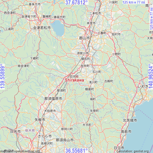
Shirakawa GPS coordinates[2]
37° 7' 10.344" North, 140° 15' 43.596" East
| Map corner | latitude | longitude |
|---|---|---|
| Upper-left | 37.67812°, | 139.55899° |
| Center: | 37.11954°, | 140.26211° |
| Lower-right: | 36.55681°, | 140.96524° |
| Map W x H: | 124.7×124.7 km | = 77.5×77.5mi |
| max Lat: | 45.40944° ⇑17.2% North |
| Shirakawa: | 37.11954° |
| min Lat: | ⇓82.8% South 24.34478° |
| min Long | Shirakawa | max Long |
| 123° | 140.26211° | 145.575° |
| W 82.5%⇐ | ⇒17.5% E |
Elevation
Elevation of Shirakawa is 323 m = 1060 ft, and this is 238.4 m = 782 ft above average elevation for this country.
| Max E: |
1086 m = 3563 ft | 6.1% |
| Shirakawa | 323 m 1060 ft | |
| Avg. | 84.6 m = 278 ft | |
Min E: |
-2 m = -7 ft | 93.9% |
See also: Japan elevation on elevation.city.
Geographical zone
Shirakawa is located in North temperate zone (between Tropic of Cancer and the Arctic Circle). Distance of this Northern Tropic circle is 1521.4 km =945.4 mi to South.| Distance of | km | miles | from Shirakawa |
|---|---|---|---|
| North Pole | 5879.8 | 3653.5 | to North |
| Arctic Circle | 3273.9 | 2034.3 | to North |
| Tropic Cancer | 1521.4 | 945.4 | to South |
| Equator | 4127.3 | 2564.6 | to South |


Nearby cities:
15 places around Shirakawa: (largest is in red/bold)
• Aizu-Wakamatsu
49.9 km =31 mi,  325°
325°
• Daigo
40 km =24.9 mi,  168°
168°
• Funehikimachi-funehiki
45.9 km =28.5 mi,  37°
37°
• Inawashiro
51.4 km =31.9 mi,  345°
345°
• Ishikawa
17 km =10.6 mi,  78°
78°
• Kuroiso
25.4 km =15.8 mi,  227°
227°
• Kōriyama
33 km =20.5 mi,  18°
18°
• Miharu
40 km =24.9 mi,  29°
29°
• Motomiya
45.5 km =28.3 mi, 15°
• Nasushiobara
28.4 km =17.6 mi,  236°
236°
• Sakura
50.6 km =31.4 mi,  208°
208°
• Sukagawa
21.1 km =13.1 mi, 30°
• Tamura
45.9 km =28.5 mi, 41°
• Yaita
46 km =28.6 mi,  219°
219°
• Ōtawara
34.7 km =21.6 mi, 215°
Sources, notices
• [Note1] Compared only with cities in Japan existing in our database
• [Src1] Map data: © OpenStreetMap contributors (CC-BY-SA)
• [Src2] Other city data from geonames.org with taken over terms of usage.
• [Src3] Geographical zone / Annual Mean Temperature by Robert A. Rohde @ Wikipedia
