Kōriyama geodata
Kōriyama (Fukushima) is a seat of a second-order administrative division; located in Japan in Asia/Tokyo (GMT+9) time zone. With population of 340,560 people, there are 53 cities with bigger population in this country. Compared to other cities in Japan, 83.5% of cities are located further ↓South; 84.6% of cities are located further ←West and 90.6% of cities have lower elevation than Kōriyama. Note1


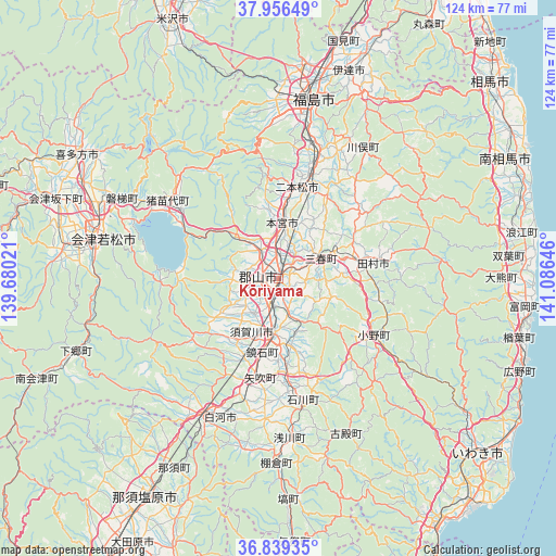
Kōriyama GPS coordinates[2]
37° 24' 0" North, 140° 22' 59.988" East
| Map corner | latitude | longitude |
|---|---|---|
| Upper-left | 37.95649°, | 139.68021° |
| Center: | 37.4°, | 140.38333° |
| Lower-right: | 36.83935°, | 141.08646° |
| Map W x H: | 124.2×124.2 km | = 77.2×77.2mi |
| max Lat: | 45.40944° ⇑16.5% North |
| Kōriyama: | 37.4° |
| min Lat: | ⇓83.5% South 24.34478° |
| min Long | Kōriyama | max Long |
| 123° | 140.38333° | 145.575° |
| W 84.6%⇐ | ⇒15.4% E |
Elevation
Elevation of Kōriyama is 236 m = 774 ft, and this is 151.4 m = 497 ft above average elevation for this country.
| Max E: |
1086 m = 3563 ft | 9.4% |
| Kōriyama | 236 m 774 ft | |
| Avg. | 84.6 m = 278 ft | |
Min E: |
-2 m = -7 ft | 90.6% |
See also: Kōriyama elevation on elevation.city.
Geographical zone
Kōriyama is located in North temperate zone (between Tropic of Cancer and the Arctic Circle). Distance of this Northern Tropic circle is 1552.6 km =964.7 mi to South.| Distance of | km | miles | from Kōriyama |
|---|---|---|---|
| North Pole | 5848.6 | 3634.2 | to North |
| Arctic Circle | 3242.7 | 2014.9 | to North |
| Tropic Cancer | 1552.6 | 964.7 | to South |
| Equator | 4158.5 | 2584 | to South |


Nearby cities:
15 places around Kōriyama: (largest is in red/bold)
• Aizu-Wakamatsu
40 km =24.9 mi,  284°
284°
• Date
47.5 km =29.5 mi,  12°
12°
• Fukushima
39.6 km =24.6 mi, 10°
• Funehikimachi-funehiki
17.9 km =11.1 mi,  72°
72°
• Hobaramachi
48.6 km =30.2 mi,  17°
17°
• Inawashiro
29.9 km =18.6 mi,  308°
308°
• Ishikawa
28.4 km =17.6 mi,  168°
168°
• Kitakata
53.4 km =33.2 mi,  301°
301°
• Miharu
9.6 km =6 mi, 67°
• Motomiya
12.8 km =8 mi, 6°
• Nihommatsu
20.9 km =13 mi, 12°
• Shirakawa
33 km =20.5 mi,  198°
198°
• Sukagawa
13 km =8.1 mi,  180°
180°
• Tamura
19.7 km =12.2 mi,  80°
80°
• Yanagawamachi-saiwaichō
53.6 km =33.3 mi, 20°
Sources, notices
• [Note1] Compared only with cities in Japan existing in our database
• [Src1] Map data: © OpenStreetMap contributors (CC-BY-SA)
• [Src2] Other city data from geonames.org with taken over terms of usage.
• [Src3] Geographical zone / Annual Mean Temperature by Robert A. Rohde @ Wikipedia
