Kamifukuoka geodata
Kamifukuoka (Saitama) is a populated place; located in Japan in Asia/Tokyo (GMT+9) time zone. With population of 52,323 people, there are 360 cities with bigger population in this country. Compared to other cities in Japan, 64.2% of cities are located further ↓South; 69% of cities are located further ←West and 53.2% of cities have higher elevation than Kamifukuoka. Note1


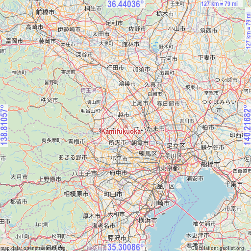
Kamifukuoka GPS coordinates[2]
35° 52' 21.576" North, 139° 30' 49.284" East
| Map corner | latitude | longitude |
|---|---|---|
| Upper-left | 36.44036°, | 138.81057° |
| Center: | 35.87266°, | 139.51369° |
| Lower-right: | 35.30086°, | 140.21682° |
| Map W x H: | 126.7×126.7 km | = 78.7×78.7mi |
| max Lat: | 45.40944° ⇑35.8% North |
| Kamifukuoka: | 35.87266° |
| min Lat: | ⇓64.2% South 24.34478° |
| min Long | Kamifukuoka | max Long |
| 123° | 139.51369° | 145.575° |
| W 69%⇐ | ⇒31% E |
Elevation
Elevation of Kamifukuoka is 25 m = 82 ft, and this is 59.6 m = 196 ft below average elevation for this country.
| Max E: |
1086 m = 3563 ft | 53.2% |
| Avg. | 84.6 m = 278 ft | |
| Kamifukuoka | 25 m = 82 ft | |
Min E: |
-2 m = -7 ft | 46.8% |
See also: Kamifukuoka elevation on elevation.city.
Geographical zone
Kamifukuoka is located in North temperate zone (between Tropic of Cancer and the Arctic Circle). Distance of this Northern Tropic circle is 1382.7 km =859.2 mi to South.| Distance of | km | miles | from Kamifukuoka |
|---|---|---|---|
| North Pole | 6018.4 | 3739.7 | to North |
| Arctic Circle | 3412.5 | 2120.4 | to North |
| Tropic Cancer | 1382.7 | 859.2 | to South |
| Equator | 3988.7 | 2478.5 | to South |


Nearby cities:
15 places around Kamifukuoka: (largest is in red/bold)
• Asaka
11 km =6.8 mi,  133°
133°
• Fujimi
4.6 km =2.9 mi, 126°
• Fujimino
1.3 km =0.8 mi,  173°
173°
• Higashikurume
13.4 km =8.3 mi,  180°
180°
• Higashiyamato
13.6 km =8.5 mi,  206°
206°
• Kawagoe
4.7 km =2.9 mi,  327°
327°
• Kiyose
10.5 km =6.5 mi, 171°
• Niiza
7 km =4.3 mi,  145°
145°
• Saitama
13.5 km =8.4 mi,  72°
72°
• Sayama
9.4 km =5.8 mi,  256°
256°
• Shiki
7.6 km =4.7 mi,  124°
124°
• Tokorozawa
9.1 km =5.7 mi, 206°
• Wako
13.5 km =8.4 mi, 133°
• Yono
10.8 km =6.7 mi,  83°
83°
• Ōi
2.5 km =1.6 mi, 166°
Sources, notices
• [Note1] Compared only with cities in Japan existing in our database
• [Src1] Map data: © OpenStreetMap contributors (CC-BY-SA)
• [Src2] Other city data from geonames.org with taken over terms of usage.
• [Src3] Geographical zone / Annual Mean Temperature by Robert A. Rohde @ Wikipedia
