Fujikawaguchiko geodata
Fujikawaguchiko (Yamanashi) is a populated place; located in Japan in Asia/Tokyo (GMT+9) time zone. With population of 23,097 people, there are 639 cities with bigger population in this country. Compared to other cities in Japan, 53.3% of cities are located further ↓South; 57.5% of cities are located further ←West and 100% of cities have lower elevation than Fujikawaguchiko. Note1
Administrative division(s):
- Level 1: Yamanashi
- Level 2: Minamitsuru-gun
- Level 3: Fujikawaguchiko-machi


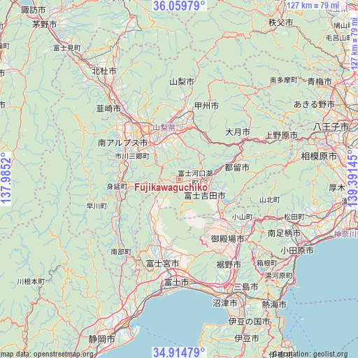
Fujikawaguchiko GPS coordinates[2]
35° 29' 21.588" North, 138° 41' 17.952" East
| Map corner | latitude | longitude |
|---|---|---|
| Upper-left | 36.05979°, | 137.9852° |
| Center: | 35.48933°, | 138.68832° |
| Lower-right: | 34.91479°, | 139.39145° |
| Map W x H: | 127.3×127.3 km | = 79.1×79.1mi |
| max Lat: | 45.40944° ⇑46.7% North |
| Fujikawaguchiko: | 35.48933° |
| min Lat: | ⇓53.3% South 24.34478° |
| min Long | Fujikawaguchiko | max Long |
| 123° | 138.68832° | 145.575° |
| W 57.5%⇐ | ⇒42.5% E |
Elevation
Elevation of Fujikawaguchiko is 1086 m = 3563 ft, and this is 1001.4 m = 3285 ft above average elevation for this country.
| Max E: |
1086 m = 3563 ft | 0% |
| Fujikawaguchiko | 1086 m 3563 ft | |
| Avg. | 84.6 m = 278 ft | |
Min E: |
-2 m = -7 ft | 100% |
See also: Japan elevation on elevation.city.
Geographical zone
Fujikawaguchiko is located in North temperate zone (between Tropic of Cancer and the Arctic Circle). Distance of this Northern Tropic circle is 1340.1 km =832.7 mi to South.| Distance of | km | miles | from Fujikawaguchiko |
|---|---|---|---|
| North Pole | 6061 | 3766.1 | to North |
| Arctic Circle | 3455.1 | 2146.9 | to North |
| Tropic Cancer | 1340.1 | 832.7 | to South |
| Equator | 3946 | 2451.9 | to South |


Nearby cities:
15 places around Fujikawaguchiko: (largest is in red/bold)
• Chūō
20.5 km =12.7 mi,  304°
304°
• Enzan
23.8 km =14.8 mi,  9°
9°
• Fuefuki
16.8 km =10.4 mi,  344°
344°
• Fuji-yoshida
11.1 km =6.9 mi,  92°
92°
• Fujiyoshida
11.2 km =7 mi,  119°
119°
• Isawa
18.5 km =11.5 mi, 344°
• Kai
27.1 km =16.8 mi,  323°
323°
• Kofu
24.9 km =15.5 mi, 338°
• Kōfu
22.6 km =14 mi,  330°
330°
• Kōshū
27.2 km =16.9 mi,  15°
15°
• Minami-Alps
24.7 km =15.3 mi, 304°
• Ryūō
24.7 km =15.3 mi, 316°
• Tsuru
21 km =13 mi,  72°
72°
• Yamanashi
20.3 km =12.6 mi,  2°
2°
• Ōtsuki
29.6 km =18.4 mi,  60°
60°
Sources, notices
• [Note1] Compared only with cities in Japan existing in our database
• [Src1] Map data: © OpenStreetMap contributors (CC-BY-SA)
• [Src2] Other city data from geonames.org with taken over terms of usage.
• [Src3] Geographical zone / Annual Mean Temperature by Robert A. Rohde @ Wikipedia
