Fujiyoshida geodata
Fujiyoshida (Yamanashi) is a populated place; located in Japan in Asia/Tokyo (GMT+9) time zone. With population of 49,055 people, there are 383 cities with bigger population in this country. Compared to other cities in Japan, 52.2% of cities are located further ↓South; 58.1% of cities are located further ←West and 99.9% of cities have lower elevation than Fujiyoshida. Note1


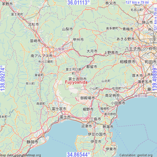
Fujiyoshida GPS coordinates[2]
35° 26' 25.152" North, 138° 47' 45.096" East
| Map corner | latitude | longitude |
|---|---|---|
| Upper-left | 36.01113°, | 138.09274° |
| Center: | 35.44032°, | 138.79586° |
| Lower-right: | 34.86544°, | 139.49899° |
| Map W x H: | 127.4×127.4 km | = 79.2×79.2mi |
| max Lat: | 45.40944° ⇑47.8% North |
| Fujiyoshida: | 35.44032° |
| min Lat: | ⇓52.2% South 24.34478° |
| min Long | Fujiyoshida | max Long |
| 123° | 138.79586° | 145.575° |
| W 58.1%⇐ | ⇒41.9% E |
Elevation
Elevation of Fujiyoshida is 1055 m = 3461 ft, and this is 970.4 m = 3184 ft above average elevation for this country.
| Max E: |
1086 m = 3563 ft | 0.099999999999994% |
| Fujiyoshida | 1055 m 3461 ft | |
| Avg. | 84.6 m = 278 ft | |
Min E: |
-2 m = -7 ft | 99.9% |
See also: Fujiyoshida elevation on elevation.city.
Geographical zone
Fujiyoshida is located in North temperate zone (between Tropic of Cancer and the Arctic Circle). Distance of this Northern Tropic circle is 1334.7 km =829.3 mi to South.| Distance of | km | miles | from Fujiyoshida |
|---|---|---|---|
| North Pole | 6066.5 | 3769.5 | to North |
| Arctic Circle | 3460.6 | 2150.3 | to North |
| Tropic Cancer | 1334.7 | 829.3 | to South |
| Equator | 3940.6 | 2448.6 | to South |


Nearby cities:
15 places around Fujiyoshida: (largest is in red/bold)
• Chūō
31.6 km =19.6 mi,  302°
302°
• Enzan
29.4 km =18.3 mi,  348°
348°
• Fuefuki
25.9 km =16.1 mi,  326°
326°
• Fuji-yoshida
5.1 km =3.2 mi,  15°
15°
• Fujikawaguchiko
11.2 km =7 mi, 299°
• Fujinomiya
29.7 km =18.5 mi,  213°
213°
• Gotenba
19 km =11.8 mi,  135°
135°
• Isawa
27.6 km =17.1 mi, 327°
• Kōshū
31.6 km =19.6 mi,  355°
355°
• Minamiashigara
31.5 km =19.6 mi,  115°
115°
• Susono
31.3 km =19.4 mi,  161°
161°
• Tsuru
15.7 km =9.8 mi,  40°
40°
• Yamakita
27.1 km =16.8 mi,  108°
108°
• Yamanashi
27.2 km =16.9 mi,  341°
341°
• Ōtsuki
25.5 km =15.8 mi, 39°
Sources, notices
• [Note1] Compared only with cities in Japan existing in our database
• [Src1] Map data: © OpenStreetMap contributors (CC-BY-SA)
• [Src2] Other city data from geonames.org with taken over terms of usage.
• [Src3] Geographical zone / Annual Mean Temperature by Robert A. Rohde @ Wikipedia
