Fuji-yoshida geodata
Fuji-yoshida (Yamanashi) is a seat of a second-order administrative division; located in Japan in Asia/Tokyo (GMT+9) time zone. In our database, there are 767 cities with bigger population. Compared to other cities in Japan, 53.1% of cities are located further ↓South; 58.3% of cities are located further ←West and 99.4% of cities have lower elevation than Fuji-yoshida. Note1


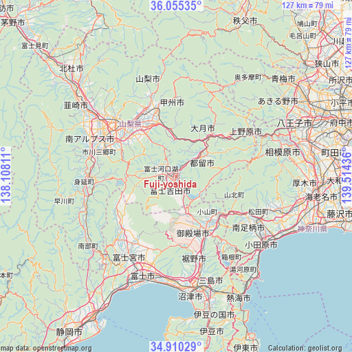
Fuji-yoshida GPS coordinates[2]
35° 29' 5.496" North, 138° 48' 40.428" East
| Map corner | latitude | longitude |
|---|---|---|
| Upper-left | 36.05535°, | 138.10811° |
| Center: | 35.48486°, | 138.81123° |
| Lower-right: | 34.91029°, | 139.51436° |
| Map W x H: | 127.3×127.3 km | = 79.1×79.1mi |
| max Lat: | 45.40944° ⇑46.9% North |
| Fuji-yoshida: | 35.48486° |
| min Lat: | ⇓53.1% South 24.34478° |
| min Long | Fuji-yoshida | max Long |
| 123° | 138.81123° | 145.575° |
| W 58.3%⇐ | ⇒41.7% E |
Elevation
Elevation of Fuji-yoshida is 777 m = 2549 ft, and this is 692.4 m = 2272 ft above average elevation for this country.
| Max E: |
1086 m = 3563 ft | 0.59999999999999% |
| Fuji-yoshida | 777 m 2549 ft | |
| Avg. | 84.6 m = 278 ft | |
Min E: |
-2 m = -7 ft | 99.4% |
See also: Japan elevation on elevation.city.
Geographical zone
Fuji-yoshida is located in North temperate zone (between Tropic of Cancer and the Arctic Circle). Distance of this Northern Tropic circle is 1339.6 km =832.4 mi to South.| Distance of | km | miles | from Fuji-yoshida |
|---|---|---|---|
| North Pole | 6061.5 | 3766.4 | to North |
| Arctic Circle | 3455.6 | 2147.2 | to North |
| Tropic Cancer | 1339.6 | 832.4 | to South |
| Equator | 3945.5 | 2451.6 | to South |


Nearby cities:
15 places around Fuji-yoshida: (largest is in red/bold)
• Chūō
30.5 km =19 mi,  293°
293°
• Enzan
24.9 km =15.5 mi,  343°
343°
• Fuefuki
22.9 km =14.2 mi,  316°
316°
• Fujikawaguchiko
11.1 km =6.9 mi,  272°
272°
• Fujiyoshida
5.1 km =3.2 mi,  195°
195°
• Gotenba
22 km =13.7 mi,  147°
147°
• Isawa
24.4 km =15.2 mi, 318°
• Kofu
31.1 km =19.3 mi, 319°
• Kōfu
30 km =18.6 mi,  312°
312°
• Kōshū
26.9 km =16.7 mi,  352°
352°
• Tsuru
11.3 km =7 mi,  52°
52°
• Uenohara
31.3 km =19.4 mi,  62°
62°
• Yamakita
27.8 km =17.3 mi,  119°
119°
• Yamanashi
23.1 km =14.4 mi,  333°
333°
• Ōtsuki
20.9 km =13 mi,  44°
44°
Sources, notices
• [Note1] Compared only with cities in Japan existing in our database
• [Src1] Map data: © OpenStreetMap contributors (CC-BY-SA)
• [Src2] Other city data from geonames.org with taken over terms of usage.
• [Src3] Geographical zone / Annual Mean Temperature by Robert A. Rohde @ Wikipedia
