Takeo geodata
Takeo is a seat of a first-order administrative division; located in Cambodia in Asia/Phnom_Penh (GMT+7) time zone. With population of 843,931 people, there is 1 city with bigger population in this country. Compared to other cities in Cambodia, 88.6% of cities are located further ↑North; 54.5% of cities are located further ←West and 80.3% of cities have higher elevation than Takeo. Note1


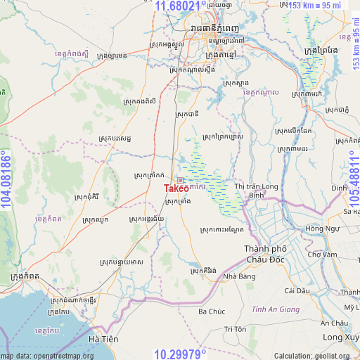
Takeo GPS coordinates[2]
10° 59' 26.916" North, 104° 47' 5.928" East
| Map corner | latitude | longitude |
|---|---|---|
| Upper-left | 11.68021°, | 104.08186° |
| Center: | 10.99081°, | 104.78498° |
| Lower-right: | 10.29979°, | 105.48811° |
| Map W x H: | 153.5×153.5 km | = 95.4×95.4mi |
| max Lat: | 14.23223° ⇑88.6% North |
| Takeo: | 10.99081° |
| min Lat: | ⇓11.4% South 10.48291° |
| min Long | Takeo | max Long |
| 102.37574° | 104.78498° | 107.42393° |
| W 54.5%⇐ | ⇒45.5% E |
Elevation
Elevation of Takeo is 12 m = 39 ft, and this is 40 m = 131 ft below average elevation for this country.
| Max E: |
678 m = 2224 ft | 80.3% |
| Avg. | 52 m = 171 ft | |
| Takeo | 12 m = 39 ft | |
Min E: |
4 m = 13 ft | 19.7% |
See also: Takeo elevation on elevation.city.
Geographical zone
Takeo is located in North Torrid zone (between Equator and Tropic of Cancer). Distance of Equator is 1222.1 km =759.4 mi to South.| Distance of | km | miles | from Takeo |
|---|---|---|---|
| North Pole | 8785 | 5458.7 | to North |
| Arctic Circle | 6179.1 | 3839.5 | to North |
| Tropic Cancer | 1383.9 | 859.9 | to North |
| Equator | 1222.1 | 759.4 | to South |


Nearby cities:
15 places around Takeo: (largest is in red/bold)
• Banteay Meas
43.5 km =27 mi,  214°
214°
• Basedth
32.3 km =20.1 mi,  302°
302°
• Bourei Cholsar
30.9 km =19.2 mi,  124°
124°
• Chhuk
39.9 km =24.8 mi,  244°
244°
• Chum Kiri
40.3 km =25 mi,  259°
259°
• Kandal Stueng
47.2 km =29.3 mi,  5°
5°
• Kiri Vongs
40.4 km =25.1 mi,  166°
166°
• Koah Thum
33.2 km =20.6 mi,  63°
63°
• Leuk Daek
52.6 km =32.7 mi,  67°
67°
• Peam Chor
49.1 km =30.5 mi,  75°
75°
• Phumĭ Véal Srê
1.3 km =0.8 mi, 213°
• S’ang
47.8 km =29.7 mi,  30°
30°
• Ta Khmau
53.6 km =33.3 mi,  19°
19°
• Ta Khmau
57.6 km =35.8 mi, 18°
• Tram Kak
12.1 km =7.5 mi,  281°
281°
Sources, notices
• [Note1] Compared only with cities in Cambodia existing in our database
• [Src1] Map data: © OpenStreetMap contributors (CC-BY-SA)
• [Src2] Other city data from geonames.org with taken over terms of usage.
• [Src3] Geographical zone / Annual Mean Temperature by Robert A. Rohde @ Wikipedia
