Krong Kep geodata
Krong Kep (Kep) is a seat of a first-order administrative division; located in Cambodia in Asia/Phnom_Penh (GMT+7) time zone. With population of 11,658 people, there are 27 cities with bigger population in this country. Compared to other cities in Cambodia, 100% of cities are located further ↑North; 60.6% of cities are located further →East and 87.9% of cities have higher elevation than Krong Kep. Note1


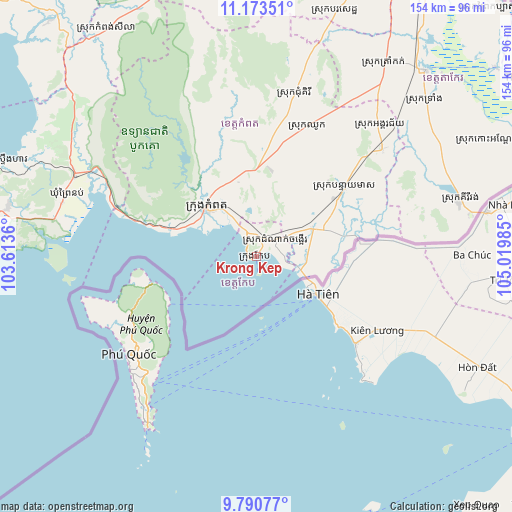
Krong Kep GPS coordinates[2]
10° 28' 58.476" North, 104° 19' 0.192" East
| Map corner | latitude | longitude |
|---|---|---|
| Upper-left | 11.17351°, | 103.6136° |
| Center: | 10.48291°, | 104.31672° |
| Lower-right: | 9.79077°, | 105.01985° |
| Map W x H: | 153.7×153.8 km | = 95.5×95.6mi |
| max Lat: | 14.23223° ⇑100% North |
| Krong Kep: | 10.48291° |
| min Lat: | ⇓0% South 10.48291° |
| min Long | Krong Kep | max Long |
| 102.37574° | 104.31672° | 107.42393° |
| W 39.4%⇐ | ⇒60.6% E |
Elevation
Elevation of Krong Kep is 8 m = 26 ft, and this is 44 m = 144 ft below average elevation for this country.
| Max E: |
678 m = 2224 ft | 87.9% |
| Avg. | 52 m = 171 ft | |
| Krong Kep | 8 m = 26 ft | |
Min E: |
4 m = 13 ft | 12.1% |
See also: Cambodia elevation on elevation.city.
Geographical zone
Krong Kep is located in North Torrid zone (between Equator and Tropic of Cancer). Distance of Equator is 1165.6 km =724.3 mi to South.| Distance of | km | miles | from Krong Kep |
|---|---|---|---|
| North Pole | 8841.5 | 5493.9 | to North |
| Arctic Circle | 6235.6 | 3874.6 | to North |
| Tropic Cancer | 1440.3 | 895 | to North |
| Equator | 1165.6 | 724.3 | to South |


Nearby cities:
15 places around Krong Kep: (largest is in red/bold)
• Banteay Meas
33.6 km =20.9 mi,  52°
52°
• Basedth
77.9 km =48.4 mi,  17°
17°
• Bourei Cholsar
86.1 km =53.5 mi,  63°
63°
• Chhuk
42.1 km =26.2 mi, 21°
• Chum Kiri
50.5 km =31.4 mi,  13°
13°
• Damnak Chang’aeur
7.8 km =4.8 mi, 47°
• Kampong Seila
81.5 km =50.6 mi,  326°
326°
• Kampong Trach
18.5 km =11.5 mi, 62°
• Kampot
15 km =9.3 mi, 333°
• Kampot
20.5 km =12.7 mi,  313°
313°
• Kiri Vongs
63.2 km =39.3 mi,  74°
74°
• Phumĭ Véal Srê
74.9 km =46.5 mi,  42°
42°
• Prey Nob
59.8 km =37.2 mi,  294°
294°
• Takeo
76.2 km =47.3 mi, 42°
• Tram Kak
70.7 km =43.9 mi,  33°
33°
Sources, notices
• [Note1] Compared only with cities in Cambodia existing in our database
• [Src1] Map data: © OpenStreetMap contributors (CC-BY-SA)
• [Src2] Other city data from geonames.org with taken over terms of usage.
• [Src3] Geographical zone / Annual Mean Temperature by Robert A. Rohde @ Wikipedia
