Rotuma Village geodata
Rotuma Village (Gilbert Islands) is a populated place; located in Kiribati in Pacific/Tarawa (GMT+12) time zone. With population of 625 people, there are 26 cities with bigger population in this country. Compared to other cities in Kiribati, 77.1% of cities are located further ↑North; 77.1% of cities are located further ←West and 88.6% of cities have higher elevation than Rotuma Village. Note1


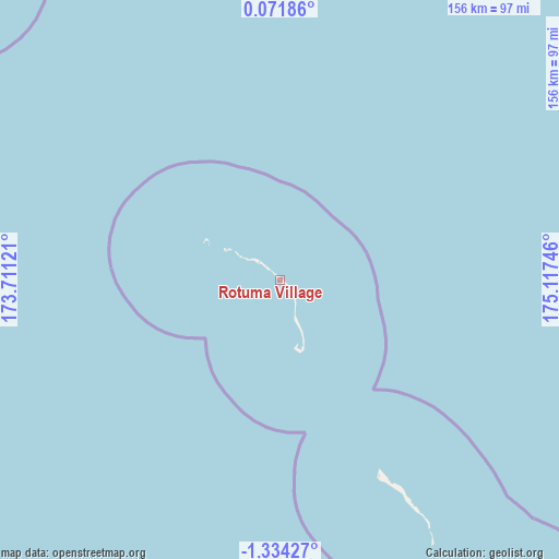
Rotuma Village GPS coordinates[2]
0° 37' 52.5" South, 174° 24' 51.588" East
| Map corner | latitude | longitude |
|---|---|---|
| Upper-left | 0.07186°, | 173.71121° |
| Center: | -0.63125°, | 174.41433° |
| Lower-right: | -1.33427°, | 175.11746° |
| Map W x H: | 156.3×156.4 km | = 97.1×97.2mi |
| max Lat: | 3.90806° ⇑77.1% North |
| Rotuma Village: | -0.63125° |
| min Lat: | ⇓22.9% South -2.65512° |
| min Long | Rotuma Village | max Long |
| -159.38832° | 174.41433° | 176.83302° |
| W 77.1%⇐ | ⇒22.9% E |
Elevation
Elevation of Rotuma Village is 8 m = 26 ft, and this is 1.9 m = 6 ft below average elevation for this country.
| Max E: |
13 m = 43 ft | 88.6% |
| Avg. | 9.9 m = 32 ft | |
| Rotuma Village | 8 m = 26 ft | |
Min E: |
6 m = 20 ft | 11.4% |
See also: Kiribati elevation on elevation.city.
Geographical zone
Rotuma Village is located in South Torrid zone (between Equator and Tropic of Capricorn). Distance of Equator is 70.2 km =43.6 mi to North.| Distance of | km | miles | from Rotuma Village |
|---|---|---|---|
| Equator | 70.2 | 43.6 | to North |
| Tropic Capricorn | 2535.7 | 1575.6 | to South |
| Antarctic Circle | 7331 | 4555.3 | to South |
| South Pole | 9936.9 | 6174.5 | to South |


Nearby cities:
15 places around Rotuma Village: (largest is in red/bold)
• Abarao Village
265 km =164.7 mi,  326°
326°
• Bikenibeu Village
264.5 km =164.4 mi, 327°
• Bonriki Village
264.9 km =164.6 mi, 327°
• Buariki Village
124.7 km =77.5 mi,  316°
316°
• Buota Village
266.3 km =165.5 mi, 327°
• Eita Village
70.1 km =43.6 mi,  150°
150°
• Eita Village
266.6 km =165.7 mi, 326°
• Matang Village
5.9 km =3.7 mi,  138°
138°
• Nawerewere Village
263.2 km =163.5 mi, 327°
• Rungata
238.2 km =148 mi,  109°
109°
• Tabiang Village
140.2 km =87.1 mi, 332°
• Tanaeang Village
63.4 km =39.4 mi, 152°
• Temaiku Village
261.8 km =162.7 mi, 327°
• Toboiaki Village
12.7 km =7.9 mi,  159°
159°
• Utiroa Village
75.3 km =46.8 mi, 149°
Sources, notices
• [Note1] Compared only with cities in Kiribati existing in our database
• [Src1] Map data: © OpenStreetMap contributors (CC-BY-SA)
• [Src2] Other city data from geonames.org with taken over terms of usage.
• [Src3] Geographical zone / Annual Mean Temperature by Robert A. Rohde @ Wikipedia
