Mohoro geodata
Mohoro (Grande Comore) is a populated place; located in Comoros in Indian/Comoro (GMT+3) time zone. With population of 2,014 people, there are 48 cities with bigger population in this country. Compared to other cities in Comoros, 61.1% of cities are located further ↓South; 53.1% of cities are located further →East and 59.3% of cities have lower elevation than Mohoro. Note1


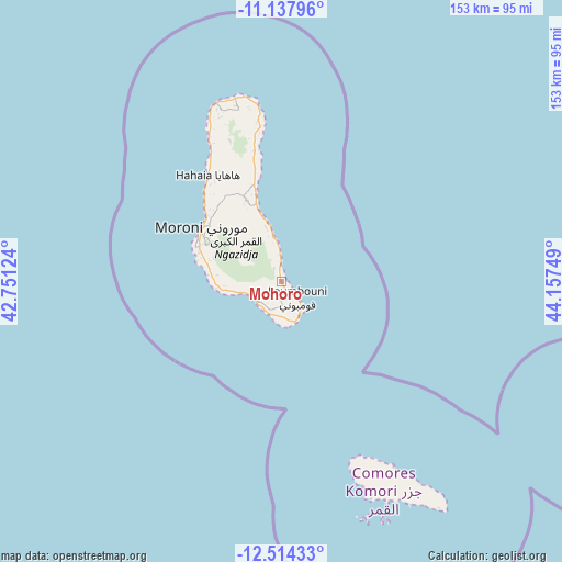
Mohoro GPS coordinates[2]
11° 49' 37.236" South, 43° 27' 15.696" East
| Map corner | latitude | longitude |
|---|---|---|
| Upper-left | -11.13796°, | 42.75124° |
| Center: | -11.82701°, | 43.45436° |
| Lower-right: | -12.51433°, | 44.15749° |
| Map W x H: | 153×153 km | = 95.1×95.1mi |
| max Lat: | -11.38472° ⇑38.9% North |
| Mohoro: | -11.82701° |
| min Lat: | ⇓61.1% South -12.37306° |
| min Long | Mohoro | max Long |
| 43.2525° | 43.45436° | 44.53194° |
| W 46.9%⇐ | ⇒53.1% E |
Elevation
Elevation of Mohoro is 164 m = 538 ft, and this is 32.1 m = 105 ft below average elevation for this country.
| Max E: |
924 m = 3031 ft | 40.7% |
| Avg. | 196.1 m = 643 ft | |
| Mohoro | 164 m = 538 ft | |
Min E: |
1 m = 3 ft | 59.3% |
See also: Comoros elevation on elevation.city.
Geographical zone
Mohoro is located in South Torrid zone (between Equator and Tropic of Capricorn). Distance of this Southern Tropic circle is 1290.9 km =802.1 mi to South.| Distance of | km | miles | from Mohoro |
|---|---|---|---|
| Equator | 1315 | 817.1 | to North |
| Tropic Capricorn | 1290.9 | 802.1 | to South |
| Antarctic Circle | 6086.1 | 3781.7 | to South |
| South Pole | 8692 | 5401 | to South |


Nearby cities:
15 places around Mohoro: (largest is in red/bold)
• Chindini
11.4 km =7.1 mi,  159°
159°
• Chouani
17.4 km =10.8 mi,  271°
271°
• Dembéni
8 km =5 mi,  229°
229°
• Dima
8.1 km =5 mi,  215°
215°
• Dzahadjou
11.7 km =7.3 mi,  255°
255°
• Foumbouni
6.2 km =3.9 mi,  133°
133°
• Hetsa
15.2 km =9.4 mi, 262°
• Kové
5.8 km =3.6 mi, 160°
• Mbambani
12.6 km =7.8 mi, 257°
• Mdjoyézi
15.3 km =9.5 mi, 266°
• Nioumamilima
3.2 km =2 mi,  196°
196°
• Oungoni
8.3 km =5.2 mi,  346°
346°
• Ourovéni
10.8 km =6.7 mi,  153°
153°
• Panda
8.5 km =5.3 mi, 231°
• Singani
15.1 km =9.4 mi, 261°
Sources, notices
• [Note1] Compared only with cities in Comoros existing in our database
• [Src1] Map data: © OpenStreetMap contributors (CC-BY-SA)
• [Src2] Other city data from geonames.org with taken over terms of usage.
• [Src3] Geographical zone / Annual Mean Temperature by Robert A. Rohde @ Wikipedia
