Chindini geodata
Chindini (Grande Comore) is a populated place; located in Comoros in Indian/Comoro (GMT+3) time zone. With population of 1,471 people, there are 66 cities with bigger population in this country. Compared to other cities in Comoros, 50.4% of cities are located further ↑North; 51.3% of cities are located further →East and 100% of cities have higher elevation than Chindini. Note1


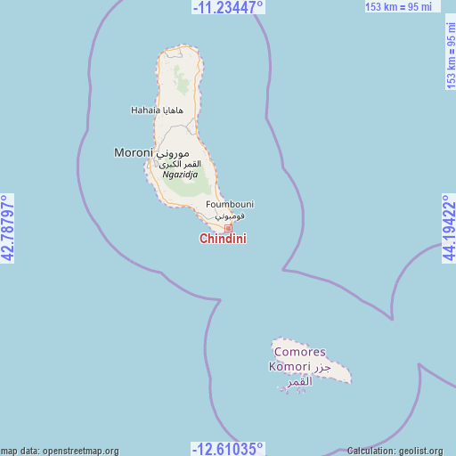
Chindini GPS coordinates[2]
11° 55' 23.808" South, 43° 29' 27.924" East
| Map corner | latitude | longitude |
|---|---|---|
| Upper-left | -11.23447°, | 42.78797° |
| Center: | -11.92328°, | 43.49109° |
| Lower-right: | -12.61035°, | 44.19422° |
| Map W x H: | 153×153 km | = 95.1×95.1mi |
| max Lat: | -11.38472° ⇑50.4% North |
| Chindini: | -11.92328° |
| min Lat: | ⇓49.6% South -12.37306° |
| min Long | Chindini | max Long |
| 43.2525° | 43.49109° | 44.53194° |
| W 48.7%⇐ | ⇒51.3% E |
Elevation
Elevation of Chindini is 1 m = 3 ft, and this is 195.1 m = 640 ft below average elevation for this country.
| Max E: |
924 m = 3031 ft | 100% |
| Avg. | 196.1 m = 643 ft | |
| Chindini | 1 m = 3 ft | |
Min E: |
1 m = 3 ft | 0% |
See also: Comoros elevation on elevation.city.
Geographical zone
Chindini is located in South Torrid zone (between Equator and Tropic of Capricorn). Distance of this Southern Tropic circle is 1280.2 km =795.5 mi to South.| Distance of | km | miles | from Chindini |
|---|---|---|---|
| Equator | 1325.7 | 823.8 | to North |
| Tropic Capricorn | 1280.2 | 795.5 | to South |
| Antarctic Circle | 6075.4 | 3775.1 | to South |
| South Pole | 8681.3 | 5394.3 | to South |


Nearby cities:
15 places around Chindini: (largest is in red/bold)
• Chouani
24.1 km =15 mi,  297°
297°
• Dembéni
11.6 km =7.2 mi, 298°
• Dima
9.6 km =6 mi, 295°
• Dzahadjou
17.2 km =10.7 mi, 296°
• Foumbouni
6.5 km =4 mi,  4°
4°
• Hetsa
21 km =13 mi,  294°
294°
• Kové
5.7 km =3.5 mi,  338°
338°
• Mbambani
18.1 km =11.2 mi, 295°
• Mdjoyézi
21.6 km =13.4 mi, 296°
• Mohoro
11.4 km =7.1 mi, 339°
• Nioumamilima
9.1 km =5.7 mi,  327°
327°
• Oungoni
19.7 km =12.2 mi, 342°
• Ourovéni
1.3 km =0.8 mi,  35°
35°
• Panda
11.9 km =7.4 mi, 296°
• Singani
20.7 km =12.9 mi, 293°
Sources, notices
• [Note1] Compared only with cities in Comoros existing in our database
• [Src1] Map data: © OpenStreetMap contributors (CC-BY-SA)
• [Src2] Other city data from geonames.org with taken over terms of usage.
• [Src3] Geographical zone / Annual Mean Temperature by Robert A. Rohde @ Wikipedia
