Séléa geodata
Séléa (Grande Comore) is a populated place; located in Comoros in Indian/Comoro (GMT+3) time zone. With population of 1,662 people, there are 60 cities with bigger population in this country. Compared to other cities in Comoros, 65.5% of cities are located further ↓South; 95.6% of cities are located further →East and 86.7% of cities have higher elevation than Séléa. Note1


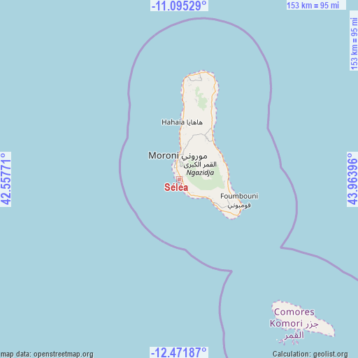
Séléa GPS coordinates[2]
11° 47' 3.984" South, 43° 15' 38.988" East
| Map corner | latitude | longitude |
|---|---|---|
| Upper-left | -11.09529°, | 42.55771° |
| Center: | -11.78444°, | 43.26083° |
| Lower-right: | -12.47187°, | 43.96396° |
| Map W x H: | 153.1×153.1 km | = 95.1×95.1mi |
| max Lat: | -11.38472° ⇑34.5% North |
| Séléa: | -11.78444° |
| min Lat: | ⇓65.5% South -12.37306° |
| min Long | Séléa | max Long |
| 43.2525° | 43.26083° | 44.53194° |
| W 4.4%⇐ | ⇒95.6% E |
Elevation
Elevation of Séléa is 24 m = 79 ft, and this is 172.1 m = 565 ft below average elevation for this country.
| Max E: |
924 m = 3031 ft | 86.7% |
| Avg. | 196.1 m = 643 ft | |
| Séléa | 24 m = 79 ft | |
Min E: |
1 m = 3 ft | 13.3% |
See also: Comoros elevation on elevation.city.
Geographical zone
Séléa is located in South Torrid zone (between Equator and Tropic of Capricorn). Distance of this Southern Tropic circle is 1295.6 km =805 mi to South.| Distance of | km | miles | from Séléa |
|---|---|---|---|
| Equator | 1310.3 | 814.2 | to North |
| Tropic Capricorn | 1295.6 | 805 | to South |
| Antarctic Circle | 6090.9 | 3784.7 | to South |
| South Pole | 8696.8 | 5403.9 | to South |


Nearby cities:
15 places around Séléa: (largest is in red/bold)
• Chouani
5.7 km =3.5 mi,  139°
139°
• Dzahadjou
12.3 km =7.6 mi,  128°
128°
• Hetsa
9 km =5.6 mi, 138°
• Itsandra
12.6 km =7.8 mi,  356°
356°
• Madjeouéni
4.5 km =2.8 mi,  155°
155°
• Mavingouni
7.6 km =4.7 mi,  353°
353°
• Mbambani
11.6 km =7.2 mi, 130°
• Mdjoyézi
8.2 km =5.1 mi, 135°
• Milembéni
13.7 km =8.5 mi,  2°
2°
• Mitsoudjé
3.7 km =2.3 mi,  145°
145°
• Moroni
9.2 km =5.7 mi, 356°
• Mvouni
7.6 km =4.7 mi, 3°
• Salimani
3.1 km =1.9 mi,  165°
165°
• Singani
9.4 km =5.8 mi, 138°
• Tsidjé
9.6 km =6 mi, 0°
Sources, notices
• [Note1] Compared only with cities in Comoros existing in our database
• [Src1] Map data: © OpenStreetMap contributors (CC-BY-SA)
• [Src2] Other city data from geonames.org with taken over terms of usage.
• [Src3] Geographical zone / Annual Mean Temperature by Robert A. Rohde @ Wikipedia
