Yeongam geodata
Yeongam (Jeollanam-do) is a seat of a second-order administrative division; located in South Korea in Asia/Seoul (GMT+9) time zone. With population of 55,000 people, there are 82 cities with bigger population in this country. Compared to other cities in South Korea, 94.8% of cities are located further ↑North; 81.8% of cities are located further →East and 55.9% of cities have higher elevation than Yeongam. Note1


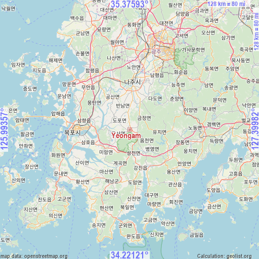
Yeongam GPS coordinates[2]
34° 48' 2.124" North, 126° 41' 48.084" East
| Map corner | latitude | longitude |
|---|---|---|
| Upper-left | 35.37593°, | 125.99357° |
| Center: | 34.80059°, | 126.69669° |
| Lower-right: | 34.22121°, | 127.39982° |
| Map W x H: | 128.4×128.4 km | = 79.8×79.8mi |
| max Lat: | 38.37881° ⇑94.8% North |
| Yeongam: | 34.80059° |
| min Lat: | ⇓5.2% South 33.25333° |
| min Long | Yeongam | max Long |
| 126.10863° | 126.69669° | 129.55377° |
| W 18.2%⇐ | ⇒81.8% E |
Elevation
Elevation of Yeongam is 34 m = 112 ft, and this is 36.4 m = 119 ft below average elevation for this country.
| Max E: |
691 m = 2267 ft | 55.9% |
| Avg. | 70.4 m = 231 ft | |
| Yeongam | 34 m = 112 ft | |
Min E: |
1 m = 3 ft | 44.1% |
See also: Yeongam elevation on elevation.city.
Geographical zone
Yeongam is located in North temperate zone (between Tropic of Cancer and the Arctic Circle). Distance of this Northern Tropic circle is 1263.5 km =785.1 mi to South.| Distance of | km | miles | from Yeongam |
|---|---|---|---|
| North Pole | 6137.6 | 3813.7 | to North |
| Arctic Circle | 3531.7 | 2194.5 | to North |
| Tropic Cancer | 1263.5 | 785.1 | to South |
| Equator | 3869.5 | 2404.4 | to South |


Nearby cities:
15 places around Yeongam: (largest is in red/bold)
• Bannam
12.3 km =7.6 mi,  340°
340°
• Cheongpung
26.4 km =16.4 mi,  71°
71°
• Deokjin
2.1 km =1.3 mi,  0°
0°
• Dopo
7 km =4.3 mi,  316°
316°
• Geumjeong
8.5 km =5.3 mi,  34°
34°
• Haenam
27 km =16.8 mi,  199°
199°
• Illo
19.8 km =12.3 mi,  286°
286°
• Iyang
28.3 km =17.6 mi, 69°
• Jangheung
23.3 km =14.5 mi,  124°
124°
• Mokpo
27.9 km =17.3 mi,  272°
272°
• Muan
29 km =18 mi, 316°
• Naju
25.5 km =15.8 mi, 4°
• Seji
14.1 km =8.8 mi,  19°
19°
• Sijong
11.2 km =7 mi,  312°
312°
• Yuchi
13 km =8.1 mi,  89°
89°
Sources, notices
• [Note1] Compared only with cities in South Korea existing in our database
• [Src1] Map data: © OpenStreetMap contributors (CC-BY-SA)
• [Src2] Other city data from geonames.org with taken over terms of usage.
• [Src3] Geographical zone / Annual Mean Temperature by Robert A. Rohde @ Wikipedia
