Kurye geodata
Kurye (Jeollanam-do) is a populated place; located in South Korea in Asia/Seoul (GMT+9) time zone. With population of 30,000 people, there are 104 cities with bigger population in this country. Compared to other cities in South Korea, 72.7% of cities are located further ↑North; 58.7% of cities are located further ←West and 52.8% of cities have lower elevation than Kurye. Note1


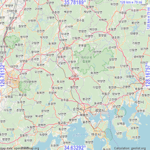
Kurye GPS coordinates[2]
35° 12' 33.984" North, 127° 27' 51.984" East
| Map corner | latitude | longitude |
|---|---|---|
| Upper-left | 35.78189°, | 126.76132° |
| Center: | 35.20944°, | 127.46444° |
| Lower-right: | 34.63292°, | 128.16757° |
| Map W x H: | 127.8×127.8 km | = 79.4×79.4mi |
| max Lat: | 38.37881° ⇑72.7% North |
| Kurye: | 35.20944° |
| min Lat: | ⇓27.3% South 33.25333° |
| min Long | Kurye | max Long |
| 126.10863° | 127.46444° | 129.55377° |
| W 58.7%⇐ | ⇒41.3% E |
Elevation
Elevation of Kurye is 46 m = 151 ft, and this is 24.4 m = 80 ft below average elevation for this country.
| Max E: |
691 m = 2267 ft | 47.2% |
| Avg. | 70.4 m = 231 ft | |
| Kurye | 46 m = 151 ft | |
Min E: |
1 m = 3 ft | 52.8% |
See also: South Korea elevation on elevation.city.
Geographical zone
Kurye is located in North temperate zone (between Tropic of Cancer and the Arctic Circle). Distance of this Northern Tropic circle is 1309 km =813.4 mi to South.| Distance of | km | miles | from Kurye |
|---|---|---|---|
| North Pole | 6092.1 | 3785.5 | to North |
| Arctic Circle | 3486.3 | 2166.3 | to North |
| Tropic Cancer | 1309 | 813.4 | to South |
| Equator | 3914.9 | 2432.6 | to South |


Nearby cities:
15 places around Kurye: (largest is in red/bold)
• Bonggang
24.4 km =15.2 mi,  154°
154°
• Donggye
32.7 km =20.3 mi,  322°
322°
• Hadong
30.5 km =19 mi,  121°
121°
• Haeryong
33.5 km =20.8 mi,  168°
168°
• Jeongnyang
31.7 km =19.7 mi, 116°
• Jinsang
31.3 km =19.4 mi,  132°
132°
• Juam
25.5 km =15.8 mi,  234°
234°
• Kwangyang
28.4 km =17.6 mi,  156°
156°
• Nangen
23.4 km =14.5 mi,  342°
342°
• Okgok
32.4 km =20.1 mi,  138°
138°
• Ongnyong
25.6 km =15.9 mi, 146°
• Sangsa
30 km =18.6 mi,  181°
181°
• Seungju
22.6 km =14 mi,  197°
197°
• Songgwang
31.8 km =19.8 mi,  215°
215°
• Suncheon
28.9 km =18 mi, 175°
Sources, notices
• [Note1] Compared only with cities in South Korea existing in our database
• [Src1] Map data: © OpenStreetMap contributors (CC-BY-SA)
• [Src2] Other city data from geonames.org with taken over terms of usage.
• [Src3] Geographical zone / Annual Mean Temperature by Robert A. Rohde @ Wikipedia
