Beonam geodata
Beonam (Jeollabuk-do) is a seat of a third-order administrative division; located in South Korea in Asia/Seoul (GMT+9) time zone. In our database, there are 128 cities with bigger population. Compared to other cities in South Korea, 60.1% of cities are located further ↑North; 62.9% of cities are located further ←West and 96.2% of cities have lower elevation than Beonam. Note1


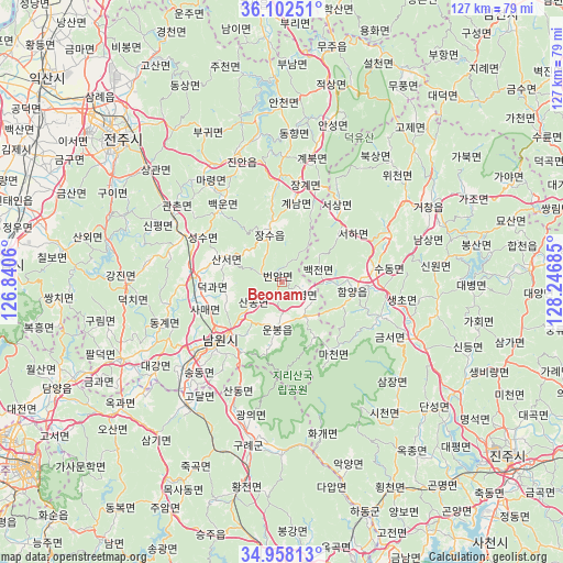
Beonam GPS coordinates[2]
35° 31' 56.496" North, 127° 32' 37.392" East
| Map corner | latitude | longitude |
|---|---|---|
| Upper-left | 36.10251°, | 126.8406° |
| Center: | 35.53236°, | 127.54372° |
| Lower-right: | 34.95813°, | 128.24685° |
| Map W x H: | 127.2×127.2 km | = 79×79mi |
| max Lat: | 38.37881° ⇑60.1% North |
| Beonam: | 35.53236° |
| min Lat: | ⇓39.9% South 33.25333° |
| min Long | Beonam | max Long |
| 126.10863° | 127.54372° | 129.55377° |
| W 62.9%⇐ | ⇒37.1% E |
Elevation
Elevation of Beonam is 254 m = 833 ft, and this is 183.6 m = 602 ft above average elevation for this country.
| Max E: |
691 m = 2267 ft | 3.8% |
| Beonam | 254 m 833 ft | |
| Avg. | 70.4 m = 231 ft | |
Min E: |
1 m = 3 ft | 96.2% |
See also: South Korea elevation on elevation.city.
Geographical zone
Beonam is located in North temperate zone (between Tropic of Cancer and the Arctic Circle). Distance of this Northern Tropic circle is 1344.9 km =835.7 mi to South.| Distance of | km | miles | from Beonam |
|---|---|---|---|
| North Pole | 6056.2 | 3763.1 | to North |
| Arctic Circle | 3450.3 | 2143.9 | to North |
| Tropic Cancer | 1344.9 | 835.7 | to South |
| Equator | 3950.8 | 2454.9 | to South |


Nearby cities:
15 places around Beonam: (largest is in red/bold)
• Baekjeon
8.6 km =5.3 mi,  74°
74°
• Byeonggok
12.5 km =7.8 mi,  90°
90°
• Changsu
13.2 km =8.2 mi,  348°
348°
• Donggye
29.1 km =18.1 mi,  249°
249°
• Gangjin
34.4 km =21.4 mi,  269°
269°
• Gurim
40.9 km =25.4 mi,  257°
257°
• Gwanchon
29.3 km =18.2 mi,  302°
302°
• Imsil
25.5 km =15.8 mi,  290°
290°
• Ingye
38.8 km =24.1 mi, 249°
• Jinan-gun
30.8 km =19.1 mi,  339°
339°
• Kurye
36.6 km =22.7 mi,  191°
191°
• Nangen
19.7 km =12.2 mi,  226°
226°
• Sanseo
14.5 km =9 mi, 293°
• Seongsu
21.9 km =13.6 mi, 299°
• Seosang
21.1 km =13.1 mi,  38°
38°
Sources, notices
• [Note1] Compared only with cities in South Korea existing in our database
• [Src1] Map data: © OpenStreetMap contributors (CC-BY-SA)
• [Src2] Other city data from geonames.org with taken over terms of usage.
• [Src3] Geographical zone / Annual Mean Temperature by Robert A. Rohde @ Wikipedia
