Ingye geodata
Ingye (Jeollabuk-do) is a seat of a third-order administrative division; located in South Korea in Asia/Seoul (GMT+9) time zone. In our database, there are 128 cities with bigger population. Compared to other cities in South Korea, 64% of cities are located further ↑North; 56.6% of cities are located further →East and 86% of cities have lower elevation than Ingye. Note1


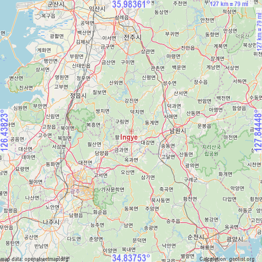
Ingye GPS coordinates[2]
35° 24' 45.396" North, 127° 8' 28.86" East
| Map corner | latitude | longitude |
|---|---|---|
| Upper-left | 35.98361°, | 126.43823° |
| Center: | 35.41261°, | 127.14135° |
| Lower-right: | 34.83753°, | 127.84448° |
| Map W x H: | 127.4×127.4 km | = 79.2×79.2mi |
| max Lat: | 38.37881° ⇑64% North |
| Ingye: | 35.41261° |
| min Lat: | ⇓36% South 33.25333° |
| min Long | Ingye | max Long |
| 126.10863° | 127.14135° | 129.55377° |
| W 43.4%⇐ | ⇒56.6% E |
Elevation
Elevation of Ingye is 137 m = 449 ft, and this is 66.6 m = 219 ft above average elevation for this country.
| Max E: |
691 m = 2267 ft | 14% |
| Ingye | 137 m 449 ft | |
| Avg. | 70.4 m = 231 ft | |
Min E: |
1 m = 3 ft | 86% |
See also: South Korea elevation on elevation.city.
Geographical zone
Ingye is located in North temperate zone (between Tropic of Cancer and the Arctic Circle). Distance of this Northern Tropic circle is 1331.6 km =827.4 mi to South.| Distance of | km | miles | from Ingye |
|---|---|---|---|
| North Pole | 6069.5 | 3771.4 | to North |
| Arctic Circle | 3463.7 | 2152.2 | to North |
| Tropic Cancer | 1331.6 | 827.4 | to South |
| Equator | 3937.5 | 2446.6 | to South |


Nearby cities:
15 places around Ingye: (largest is in red/bold)
• Changpyeong
22.3 km =13.9 mi,  210°
210°
• Chilbo
25.1 km =15.6 mi,  327°
327°
• Damyang
17.7 km =11 mi,  233°
233°
• Donggye
9.7 km =6 mi,  70°
70°
• Gangjin
13.2 km =8.2 mi,  8°
8°
• Gurim
5.8 km =3.6 mi,  322°
322°
• Gwanchon
31.4 km =19.5 mi,  21°
21°
• Imsil
25.6 km =15.9 mi,  29°
29°
• Jangseong
34.8 km =21.6 mi,  248°
248°
• Jeongeup
29.1 km =18.1 mi, 315°
• Nangen
22.2 km =13.8 mi,  90°
90°
• Sannae
20 km =12.4 mi, 329°
• Sanseo
29.9 km =18.6 mi,  50°
50°
• Seongsu
29.9 km =18.6 mi,  35°
35°
• Ssangchi
16 km =9.9 mi,  308°
308°
Sources, notices
• [Note1] Compared only with cities in South Korea existing in our database
• [Src1] Map data: © OpenStreetMap contributors (CC-BY-SA)
• [Src2] Other city data from geonames.org with taken over terms of usage.
• [Src3] Geographical zone / Annual Mean Temperature by Robert A. Rohde @ Wikipedia
