Yeosu geodata
Yeosu (Jeollanam-do) is a seat of a second-order administrative division; located in South Korea in Asia/Seoul (GMT+9) time zone. With population of 295,538 people, there are 25 cities with bigger population in this country. Compared to other cities in South Korea, 97.2% of cities are located further ↑North; 67.8% of cities are located further ←West and 92% of cities have higher elevation than Yeosu. Note1


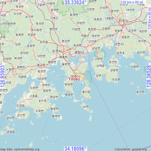
Yeosu GPS coordinates[2]
34° 45' 38.232" North, 127° 39' 43.74" East
| Map corner | latitude | longitude |
|---|---|---|
| Upper-left | 35.33624°, | 126.95903° |
| Center: | 34.76062°, | 127.66215° |
| Lower-right: | 34.18096°, | 128.36528° |
| Map W x H: | 128.5×128.5 km | = 79.8×79.8mi |
| max Lat: | 38.37881° ⇑97.2% North |
| Yeosu: | 34.76062° |
| min Lat: | ⇓2.8% South 33.25333° |
| min Long | Yeosu | max Long |
| 126.10863° | 127.66215° | 129.55377° |
| W 67.8%⇐ | ⇒32.2% E |
Elevation
Elevation of Yeosu is 10 m = 33 ft, and this is 60.4 m = 198 ft below average elevation for this country.
| Max E: |
691 m = 2267 ft | 92% |
| Avg. | 70.4 m = 231 ft | |
| Yeosu | 10 m = 33 ft | |
Min E: |
1 m = 3 ft | 8% |
See also: Yeosu elevation on elevation.city.
Geographical zone
Yeosu is located in North temperate zone (between Tropic of Cancer and the Arctic Circle). Distance of this Northern Tropic circle is 1259.1 km =782.4 mi to South.| Distance of | km | miles | from Yeosu |
|---|---|---|---|
| North Pole | 6142 | 3816.5 | to North |
| Arctic Circle | 3536.2 | 2197.3 | to North |
| Tropic Cancer | 1259.1 | 782.4 | to South |
| Equator | 3865 | 2401.6 | to South |


Nearby cities:
15 places around Yeosu: (largest is in red/bold)
• Bonggang
28.9 km =18 mi,  345°
345°
• Byeollyang
23 km =14.3 mi,  303°
303°
• Geumseong
25.5 km =15.8 mi,  27°
27°
• Gwangyang
20.3 km =12.6 mi,  8°
8°
• Haeryong
20.5 km =12.7 mi,  326°
326°
• Hwayang
7.3 km =4.5 mi,  217°
217°
• Jinwol
25.8 km =16 mi,  19°
19°
• Kwangyang
24.8 km =15.4 mi,  344°
344°
• Nammyeon
20.6 km =12.8 mi,  86°
86°
• Okgok
25.8 km =16 mi, 7°
• Ongnyong
28.8 km =17.9 mi, 352°
• Sangsa
27.4 km =17 mi,  316°
316°
• Sora
4.5 km =2.8 mi, 323°
• Suncheon
26.4 km =16.4 mi, 323°
• Yulchon
15.5 km =9.6 mi, 330°
Sources, notices
• [Note1] Compared only with cities in South Korea existing in our database
• [Src1] Map data: © OpenStreetMap contributors (CC-BY-SA)
• [Src2] Other city data from geonames.org with taken over terms of usage.
• [Src3] Geographical zone / Annual Mean Temperature by Robert A. Rohde @ Wikipedia
