Nasan geodata
Nasan (Jeollanam-do) is a seat of a third-order administrative division; located in South Korea in Asia/Seoul (GMT+9) time zone. In our database, there are 128 cities with bigger population. Compared to other cities in South Korea, 75.2% of cities are located further ↑North; 83.9% of cities are located further →East and 92% of cities have higher elevation than Nasan. Note1


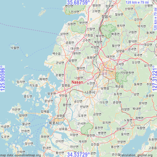
Nasan GPS coordinates[2]
35° 6' 52.092" North, 126° 36' 32.688" East
| Map corner | latitude | longitude |
|---|---|---|
| Upper-left | 35.68759°, | 125.90596° |
| Center: | 35.11447°, | 126.60908° |
| Lower-right: | 34.53729°, | 127.31221° |
| Map W x H: | 127.9×127.9 km | = 79.5×79.5mi |
| max Lat: | 38.37881° ⇑75.2% North |
| Nasan: | 35.11447° |
| min Lat: | ⇓24.8% South 33.25333° |
| min Long | Nasan | max Long |
| 126.10863° | 126.60908° | 129.55377° |
| W 16.1%⇐ | ⇒83.9% E |
Elevation
Elevation of Nasan is 10 m = 33 ft, and this is 60.4 m = 198 ft below average elevation for this country.
| Max E: |
691 m = 2267 ft | 92% |
| Avg. | 70.4 m = 231 ft | |
| Nasan | 10 m = 33 ft | |
Min E: |
1 m = 3 ft | 8% |
See also: South Korea elevation on elevation.city.
Geographical zone
Nasan is located in North temperate zone (between Tropic of Cancer and the Arctic Circle). Distance of this Northern Tropic circle is 1298.4 km =806.8 mi to South.| Distance of | km | miles | from Nasan |
|---|---|---|---|
| North Pole | 6102.7 | 3792 | to North |
| Arctic Circle | 3496.8 | 2172.8 | to North |
| Tropic Cancer | 1298.4 | 806.8 | to South |
| Equator | 3904.4 | 2426.1 | to South |


Nearby cities:
15 places around Nasan: (largest is in red/bold)
• Baeksu
25.5 km =15.8 mi,  317°
317°
• Bannam
23.7 km =14.7 mi,  170°
170°
• Bulgap
14 km =8.7 mi, 318°
• Daema
21 km =13 mi,  352°
352°
• Daesan
25.3 km =15.7 mi,  358°
358°
• Gunnam
19.9 km =12.4 mi,  314°
314°
• Gunseo
20.1 km =12.5 mi, 322°
• Haebo
7.5 km =4.7 mi, 354°
• Masan
20.3 km =12.6 mi,  85°
85°
• Muan
18.2 km =11.3 mi,  220°
220°
• Myoryang
17 km =10.6 mi,  339°
339°
• Naju
13.7 km =8.5 mi,  133°
133°
• Seji
25.1 km =15.6 mi,  149°
149°
• Yeomsan
24.5 km =15.2 mi,  298°
298°
• Yeonggwang
20.2 km =12.6 mi,  334°
334°
Sources, notices
• [Note1] Compared only with cities in South Korea existing in our database
• [Src1] Map data: © OpenStreetMap contributors (CC-BY-SA)
• [Src2] Other city data from geonames.org with taken over terms of usage.
• [Src3] Geographical zone / Annual Mean Temperature by Robert A. Rohde @ Wikipedia
