Masan geodata
Masan (Gwangju) is a populated place; located in South Korea in Asia/Seoul (GMT+9) time zone. With population of 434,371 people, there are 19 cities with bigger population in this country. Compared to other cities in South Korea, 74.8% of cities are located further ↑North; 75.5% of cities are located further →East and 75.5% of cities have higher elevation than Masan. Note1


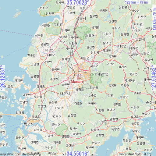
Masan GPS coordinates[2]
35° 7' 38.1" North, 126° 49' 53.364" East
| Map corner | latitude | longitude |
|---|---|---|
| Upper-left | 35.70028°, | 126.12837° |
| Center: | 35.12725°, | 126.83149° |
| Lower-right: | 34.55016°, | 127.53462° |
| Map W x H: | 127.9×127.9 km | = 79.5×79.5mi |
| max Lat: | 38.37881° ⇑74.8% North |
| Masan: | 35.12725° |
| min Lat: | ⇓25.2% South 33.25333° |
| min Long | Masan | max Long |
| 126.10863° | 126.83149° | 129.55377° |
| W 24.5%⇐ | ⇒75.5% E |
Elevation
Elevation of Masan is 18 m = 59 ft, and this is 52.4 m = 172 ft below average elevation for this country.
| Max E: |
691 m = 2267 ft | 75.5% |
| Avg. | 70.4 m = 231 ft | |
| Masan | 18 m = 59 ft | |
Min E: |
1 m = 3 ft | 24.5% |
See also: Masan elevation on elevation.city.
Geographical zone
Masan is located in North temperate zone (between Tropic of Cancer and the Arctic Circle). Distance of this Northern Tropic circle is 1299.9 km =807.7 mi to South.| Distance of | km | miles | from Masan |
|---|---|---|---|
| North Pole | 6101.3 | 3791.2 | to North |
| Arctic Circle | 3495.4 | 2171.9 | to North |
| Tropic Cancer | 1299.9 | 807.7 | to South |
| Equator | 3905.8 | 2427 | to South |


Nearby cities:
15 places around Masan: (largest is in red/bold)
• Bannam
29.7 km =18.5 mi,  213°
213°
• Changpyeong
21 km =13 mi,  53°
53°
• Damyang
25.4 km =15.8 mi,  33°
33°
• Dongbok
27.9 km =17.3 mi,  103°
103°
• Dongmyeon
21.7 km =13.5 mi,  119°
119°
• Gwangju
8.2 km =5.1 mi,  68°
68°
• Haebo
21.8 km =13.5 mi,  285°
285°
• Hancheolli
22.9 km =14.2 mi,  137°
137°
• Hwasun
16 km =9.9 mi, 117°
• Jangseong
19.4 km =12.1 mi,  347°
347°
• Myoryang
29.9 km =18.6 mi,  298°
298°
• Naju
15 km =9.3 mi,  223°
223°
• Nammyeon
27.5 km =17.1 mi, 118°
• Nasan
20.3 km =12.6 mi,  265°
265°
• Seji
24.2 km =15 mi,  197°
197°
Sources, notices
• [Note1] Compared only with cities in South Korea existing in our database
• [Src1] Map data: © OpenStreetMap contributors (CC-BY-SA)
• [Src2] Other city data from geonames.org with taken over terms of usage.
• [Src3] Geographical zone / Annual Mean Temperature by Robert A. Rohde @ Wikipedia
