Naju geodata
Naju (Jeollanam-do) is a seat of a second-order administrative division; located in South Korea in Asia/Seoul (GMT+9) time zone. With population of 42,459 people, there are 91 cities with bigger population in this country. Compared to other cities in South Korea, 79% of cities are located further ↑North; 79.7% of cities are located further →East and 66.1% of cities have higher elevation than Naju. Note1


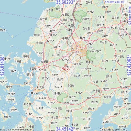
Naju GPS coordinates[2]
35° 1' 45.12" North, 126° 43' 3" East
| Map corner | latitude | longitude |
|---|---|---|
| Upper-left | 35.60293°, | 126.01438° |
| Center: | 35.0292°, | 126.7175° |
| Lower-right: | 34.45142°, | 127.42063° |
| Map W x H: | 128×128 km | = 79.5×79.5mi |
| max Lat: | 38.37881° ⇑79% North |
| Naju: | 35.0292° |
| min Lat: | ⇓21% South 33.25333° |
| min Long | Naju | max Long |
| 126.10863° | 126.7175° | 129.55377° |
| W 20.3%⇐ | ⇒79.7% E |
Elevation
Elevation of Naju is 25 m = 82 ft, and this is 45.4 m = 149 ft below average elevation for this country.
| Max E: |
691 m = 2267 ft | 66.1% |
| Avg. | 70.4 m = 231 ft | |
| Naju | 25 m = 82 ft | |
Min E: |
1 m = 3 ft | 33.9% |
See also: Naju elevation on elevation.city.
Geographical zone
Naju is located in North temperate zone (between Tropic of Cancer and the Arctic Circle). Distance of this Northern Tropic circle is 1289 km =800.9 mi to South.| Distance of | km | miles | from Naju |
|---|---|---|---|
| North Pole | 6112.2 | 3797.9 | to North |
| Arctic Circle | 3506.3 | 2178.7 | to North |
| Tropic Cancer | 1289 | 800.9 | to South |
| Equator | 3894.9 | 2420.2 | to South |


Nearby cities:
15 places around Naju: (largest is in red/bold)
• Bannam
15.1 km =9.4 mi,  203°
203°
• Deokjin
23.4 km =14.5 mi,  184°
184°
• Dopo
21.5 km =13.4 mi, 198°
• Geumjeong
18.6 km =11.6 mi,  171°
171°
• Gwangju
22.8 km =14.2 mi,  52°
52°
• Haebo
19.9 km =12.4 mi,  327°
327°
• Hancheolli
26.5 km =16.5 mi,  103°
103°
• Hwasun
24.8 km =15.4 mi,  81°
81°
• Masan
15 km =9.3 mi,  43°
43°
• Muan
22.2 km =13.8 mi,  258°
258°
• Nasan
13.7 km =8.5 mi,  313°
313°
• Seji
12.5 km =7.8 mi, 166°
• Sijong
20.5 km =12.7 mi,  209°
209°
• Yeongam
25.5 km =15.8 mi, 184°
• Yuchi
27.5 km =17.1 mi,  156°
156°
Sources, notices
• [Note1] Compared only with cities in South Korea existing in our database
• [Src1] Map data: © OpenStreetMap contributors (CC-BY-SA)
• [Src2] Other city data from geonames.org with taken over terms of usage.
• [Src3] Geographical zone / Annual Mean Temperature by Robert A. Rohde @ Wikipedia
