Jonava geodata
Jonava (Kaunas) is a populated place; located in Lithuania in Europe/Vilnius (GMT+3) time zone. With population of 34,993 people, there are 12 cities with bigger population in this country. Compared to other cities in Lithuania, 50.7% of cities are located further ↑North; 60.4% of cities are located further ←West and 64.9% of cities have higher elevation than Jonava. Note1


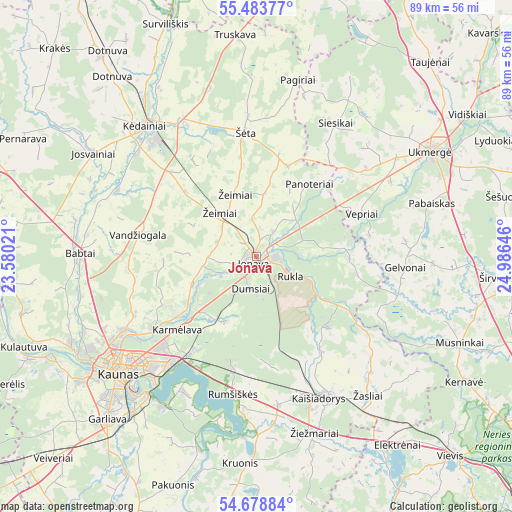
Jonava GPS coordinates[2]
55° 4' 59.988" North, 24° 16' 59.988" East
| Map corner | latitude | longitude |
|---|---|---|
| Upper-left | 55.48377°, | 23.58021° |
| Center: | 55.08333°, | 24.28333° |
| Lower-right: | 54.67884°, | 24.98646° |
| Map W x H: | 89.5×89.5 km | = 55.6×55.6mi |
| max Lat: | 56.36149° ⇑50.7% North |
| Jonava: | 55.08333° |
| min Lat: | ⇓49.3% South 54.01573° |
| min Long | Jonava | max Long |
| 20.99651° | 24.28333° | 26.43984° |
| W 60.4%⇐ | ⇒39.6% E |
Elevation
Elevation of Jonava is 70 m = 230 ft, and this is 20.7 m = 68 ft below average elevation for this country.
| Max E: |
204 m = 669 ft | 64.9% |
| Avg. | 90.7 m = 298 ft | |
| Jonava | 70 m = 230 ft | |
Min E: |
-1 m = -3 ft | 35.1% |
See also: Lithuania elevation on elevation.city.
Geographical zone
Jonava is located in North temperate zone (between Tropic of Cancer and the Arctic Circle). Distance of this North polar circle is 1276.5 km =793.2 mi to North.| Distance of | km | miles | from Jonava |
|---|---|---|---|
| North Pole | 3882.4 | 2412.4 | to North |
| Arctic Circle | 1276.5 | 793.2 | to North |
| Tropic Cancer | 3518.8 | 2186.5 | to South |
| Equator | 6124.7 | 3805.7 | to South |


Nearby cities:
15 places around Jonava: (largest is in red/bold)
• Akademija (Kaunas)
35.9 km =22.3 mi,  234°
234°
• Aleksotas
32.9 km =20.4 mi, 226°
• Dainava (Kaunas)
27.4 km =17 mi, 227°
• Eiguliai
28 km =17.4 mi, 232°
• Kaišiadorys
27 km =16.8 mi,  154°
154°
• Karmėlava
18.9 km =11.7 mi, 228°
• Kaunas
31.2 km =19.4 mi, 229°
• Kėdainiai
30.1 km =18.7 mi,  319°
319°
• Noreikiškės
35.3 km =21.9 mi, 231°
• Ramučiai
22 km =13.7 mi, 227°
• Sargėnai
29.5 km =18.3 mi,  239°
239°
• Ukmerge
35 km =21.7 mi,  57°
57°
• Vepriai
19.9 km =12.4 mi,  67°
67°
• Šilainiai
30.6 km =19 mi, 235°
• Žiežmariai
32.3 km =20.1 mi,  161°
161°
Sources, notices
• [Note1] Compared only with cities in Lithuania existing in our database
• [Src1] Map data: © OpenStreetMap contributors (CC-BY-SA)
• [Src2] Other city data from geonames.org with taken over terms of usage.
• [Src3] Geographical zone / Annual Mean Temperature by Robert A. Rohde @ Wikipedia
