Šilainiai geodata
Šilainiai (Kaunas) is a section of populated place; located in Lithuania in Europe/Vilnius (GMT+3) time zone. With population of 40,600 people, there are 10 cities with bigger population in this country. Compared to other cities in Lithuania, 61.2% of cities are located further ↑North; 51.5% of cities are located further →East and 67.9% of cities have higher elevation than Šilainiai. Note1


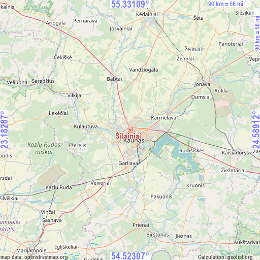
Šilainiai GPS coordinates[2]
54° 55' 44.796" North, 23° 53' 9.564" East
| Map corner | latitude | longitude |
|---|---|---|
| Upper-left | 55.33109°, | 23.18287° |
| Center: | 54.92911°, | 23.88599° |
| Lower-right: | 54.52307°, | 24.58912° |
| Map W x H: | 89.8×89.8 km | = 55.8×55.8mi |
| max Lat: | 56.36149° ⇑61.2% North |
| Šilainiai: | 54.92911° |
| min Lat: | ⇓38.8% South 54.01573° |
| min Long | Šilainiai | max Long |
| 20.99651° | 23.88599° | 26.43984° |
| W 48.5%⇐ | ⇒51.5% E |
Elevation
Elevation of Šilainiai is 68 m = 223 ft, and this is 22.7 m = 74 ft below average elevation for this country.
| Max E: |
204 m = 669 ft | 67.9% |
| Avg. | 90.7 m = 298 ft | |
| Šilainiai | 68 m = 223 ft | |
Min E: |
-1 m = -3 ft | 32.1% |
See also: Šilainiai elevation on elevation.city.
Geographical zone
Šilainiai is located in North temperate zone (between Tropic of Cancer and the Arctic Circle). Distance of this North polar circle is 1293.6 km =803.8 mi to North.| Distance of | km | miles | from Šilainiai |
|---|---|---|---|
| North Pole | 3899.5 | 2423 | to North |
| Arctic Circle | 1293.6 | 803.8 | to North |
| Tropic Cancer | 3501.6 | 2175.8 | to South |
| Equator | 6107.5 | 3795 | to South |


Nearby cities:
15 places around Šilainiai: (largest is in red/bold)
• Akademija (Kaunas)
5.4 km =3.4 mi,  227°
227°
• Aleksotas
5.6 km =3.5 mi,  165°
165°
• Dainava (Kaunas)
5.5 km =3.4 mi,  106°
106°
• Eiguliai
3 km =1.9 mi,  85°
85°
• Ežerėlis
18.7 km =11.6 mi,  254°
254°
• Garliava
12 km =7.5 mi,  184°
184°
• Karmėlava
12.1 km =7.5 mi,  67°
67°
• Kaunas
3.3 km =2.1 mi,  152°
152°
• Kačerginė
10.9 km =6.8 mi,  272°
272°
• Kulautuva
15.6 km =9.7 mi,  275°
275°
• Linksmakalnis
19.2 km =11.9 mi, 171°
• Mastaiciai
12.4 km =7.7 mi,  192°
192°
• Noreikiškės
5.2 km =3.2 mi,  207°
207°
• Ramučiai
9.5 km =5.9 mi,  76°
76°
• Sargėnai
2.3 km =1.4 mi,  355°
355°
Sources, notices
• [Note1] Compared only with cities in Lithuania existing in our database
• [Src1] Map data: © OpenStreetMap contributors (CC-BY-SA)
• [Src2] Other city data from geonames.org with taken over terms of usage.
• [Src3] Geographical zone / Annual Mean Temperature by Robert A. Rohde @ Wikipedia
