Kaunas geodata
Kaunas is a seat of a first-order administrative division; located in Lithuania in Europe/Vilnius (GMT+3) time zone. With population of 374,643 people, there is 1 city with bigger population in this country. Compared to other cities in Lithuania, 62.7% of cities are located further ↑North; 50% of cities are located further ←West and 57.5% of cities have higher elevation than Kaunas. Note1


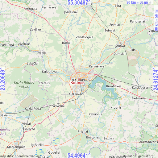
Kaunas GPS coordinates[2]
54° 54' 9.792" North, 23° 54' 34.596" East
| Map corner | latitude | longitude |
|---|---|---|
| Upper-left | 55.30497°, | 23.20649° |
| Center: | 54.90272°, | 23.90961° |
| Lower-right: | 54.49641°, | 24.61274° |
| Map W x H: | 89.9×89.9 km | = 55.9×55.9mi |
| max Lat: | 56.36149° ⇑62.7% North |
| Kaunas: | 54.90272° |
| min Lat: | ⇓37.3% South 54.01573° |
| min Long | Kaunas | max Long |
| 20.99651° | 23.90961° | 26.43984° |
| W 50%⇐ | ⇒50% E |
Elevation
Elevation of Kaunas is 74 m = 243 ft, and this is 16.7 m = 55 ft below average elevation for this country.
| Max E: |
204 m = 669 ft | 57.5% |
| Avg. | 90.7 m = 298 ft | |
| Kaunas | 74 m = 243 ft | |
Min E: |
-1 m = -3 ft | 42.5% |
See also: Kaunas elevation on elevation.city.
Geographical zone
Kaunas is located in North temperate zone (between Tropic of Cancer and the Arctic Circle). Distance of this North polar circle is 1296.6 km =805.7 mi to North.| Distance of | km | miles | from Kaunas |
|---|---|---|---|
| North Pole | 3902.5 | 2424.9 | to North |
| Arctic Circle | 1296.6 | 805.7 | to North |
| Tropic Cancer | 3498.7 | 2174 | to South |
| Equator | 6104.6 | 3793.2 | to South |


Nearby cities:
15 places around Kaunas: (largest is in red/bold)
• Akademija (Kaunas)
5.5 km =3.4 mi,  262°
262°
• Aleksotas
2.5 km =1.6 mi,  181°
181°
• Dainava (Kaunas)
4 km =2.5 mi,  69°
69°
• Eiguliai
3.5 km =2.2 mi,  24°
24°
• Ežerėlis
19.7 km =12.2 mi, 263°
• Garliava
9.4 km =5.8 mi,  195°
195°
• Karmėlava
12.3 km =7.6 mi,  52°
52°
• Kačerginė
12.8 km =8 mi,  285°
285°
• Kulautuva
17.6 km =10.9 mi,  284°
284°
• Linksmakalnis
16.1 km =10 mi, 175°
• Mastaiciai
10.1 km =6.3 mi, 204°
• Noreikiškės
4.3 km =2.7 mi,  246°
246°
• Ramučiai
9.2 km =5.7 mi,  56°
56°
• Sargėnai
5.5 km =3.4 mi,  341°
341°
• Šilainiai
3.3 km =2.1 mi,  332°
332°
Sources, notices
• [Note1] Compared only with cities in Lithuania existing in our database
• [Src1] Map data: © OpenStreetMap contributors (CC-BY-SA)
• [Src2] Other city data from geonames.org with taken over terms of usage.
• [Src3] Geographical zone / Annual Mean Temperature by Robert A. Rohde @ Wikipedia
