Dainava (Kaunas) geodata
Dainava (Kaunas) (Kaunas) is a section of populated place; located in Lithuania in Europe/Vilnius (GMT+3) time zone. With population of 70,000 people, there are 6 cities with bigger population in this country. Compared to other cities in Lithuania, 61.9% of cities are located further ↑North; 53% of cities are located further ←West and 64.9% of cities have higher elevation than Dainava (Kaunas). Note1


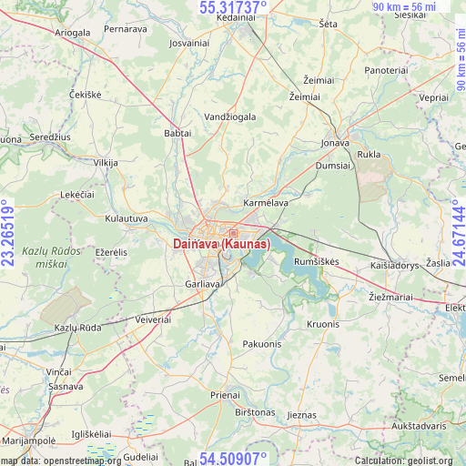
Dainava (Kaunas) GPS coordinates[2]
54° 54' 54.9" North, 23° 58' 5.916" East
| Map corner | latitude | longitude |
|---|---|---|
| Upper-left | 55.31737°, | 23.26519° |
| Center: | 54.91525°, | 23.96831° |
| Lower-right: | 54.50907°, | 24.67144° |
| Map W x H: | 89.9×89.9 km | = 55.9×55.9mi |
| max Lat: | 56.36149° ⇑61.9% North |
| Dainava (Kaunas): | 54.91525° |
| min Lat: | ⇓38.1% South 54.01573° |
| min Long | Dainava (Kaunas | max Long |
| 20.99651° | 23.96831° | 26.43984° |
| W 53%⇐ | ⇒47% E |
Elevation
Elevation of Dainava (Kaunas) is 70 m = 230 ft, and this is 20.7 m = 68 ft below average elevation for this country.
| Max E: |
204 m = 669 ft | 64.9% |
| Avg. | 90.7 m = 298 ft | |
| Dainava (Kaunas) | 70 m = 230 ft | |
Min E: |
-1 m = -3 ft | 35.1% |
See also: Dainava (Kaunas) elevation on elevation.city.
Geographical zone
Dainava (Kaunas) is located in North temperate zone (between Tropic of Cancer and the Arctic Circle). Distance of this North polar circle is 1295.2 km =804.8 mi to North.| Distance of | km | miles | from Dainava (Kaunas) |
|---|---|---|---|
| North Pole | 3901.1 | 2424 | to North |
| Arctic Circle | 1295.2 | 804.8 | to North |
| Tropic Cancer | 3500.1 | 2174.9 | to South |
| Equator | 6106 | 3794.1 | to South |


Nearby cities:
15 places around Dainava (Kaunas): (largest is in red/bold)
• Akademija (Kaunas)
9.5 km =5.9 mi,  257°
257°
• Aleksotas
5.5 km =3.4 mi,  224°
224°
• Eiguliai
2.9 km =1.8 mi,  307°
307°
• Ežerėlis
23.6 km =14.7 mi, 261°
• Garliava
12.1 km =7.5 mi,  210°
210°
• Karmėlava
8.6 km =5.3 mi,  44°
44°
• Kaunas
4 km =2.5 mi,  249°
249°
• Kačerginė
16.2 km =10.1 mi,  277°
277°
• Kulautuva
21 km =13 mi, 278°
• Linksmakalnis
17.7 km =11 mi,  188°
188°
• Mastaiciai
13.2 km =8.2 mi, 216°
• Noreikiškės
8.3 km =5.2 mi, 248°
• Ramučiai
5.4 km =3.4 mi,  47°
47°
• Sargėnai
6.6 km =4.1 mi,  304°
304°
• Šilainiai
5.5 km =3.4 mi,  286°
286°
Sources, notices
• [Note1] Compared only with cities in Lithuania existing in our database
• [Src1] Map data: © OpenStreetMap contributors (CC-BY-SA)
• [Src2] Other city data from geonames.org with taken over terms of usage.
• [Src3] Geographical zone / Annual Mean Temperature by Robert A. Rohde @ Wikipedia
