Saldus geodata
Saldus (Saldus Rajons) is a seat of a first-order administrative division; located in Latvia in Europe/Riga (GMT+3) time zone. With population of 12,224 people, there are 16 cities with bigger population in this country. Compared to other cities in Latvia, 66.4% of cities are located further ↑North; 87.9% of cities are located further →East and 70.7% of cities have lower elevation than Saldus. Note1


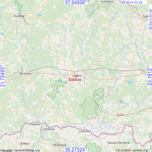
Saldus GPS coordinates[2]
56° 39' 49.068" North, 22° 29' 17.052" East
| Map corner | latitude | longitude |
|---|---|---|
| Upper-left | 57.04806°, | 21.78495° |
| Center: | 56.66363°, | 22.48807° |
| Lower-right: | 56.27524°, | 23.1912° |
| Map W x H: | 85.9×85.9 km | = 53.4×53.4mi |
| max Lat: | 57.89752° ⇑66.4% North |
| Saldus: | 56.66363° |
| min Lat: | ⇓33.6% South 55.75284° |
| min Long | Saldus | max Long |
| 21.01085° | 22.48807° | 28.12165° |
| W 12.1%⇐ | ⇒87.9% E |
Elevation
Elevation of Saldus is 92 m = 302 ft, and this is 26.6 m = 87 ft above average elevation for this country.
| Max E: |
212 m = 696 ft | 29.3% |
| Saldus | 92 m 302 ft | |
| Avg. | 65.4 m = 215 ft | |
Min E: |
2 m = 7 ft | 70.7% |
See also: Latvia elevation on elevation.city.
Geographical zone
Saldus is located in North temperate zone (between Tropic of Cancer and the Arctic Circle). Distance of this North polar circle is 1100.8 km =684 mi to North.| Distance of | km | miles | from Saldus |
|---|---|---|---|
| North Pole | 3706.7 | 2303.2 | to North |
| Arctic Circle | 1100.8 | 684 | to North |
| Tropic Cancer | 3694.5 | 2295.7 | to South |
| Equator | 6300.4 | 3914.9 | to South |


Nearby cities:
15 places around Saldus: (largest is in red/bold)
• Aizpute
54.5 km =33.9 mi,  276°
276°
• Auce
34 km =21.1 mi,  131°
131°
• Brocēni
5.3 km =3.3 mi,  71°
71°
• Dobele
48.3 km =30 mi,  95°
95°
• Jaunpils
32.9 km =20.4 mi,  76°
76°
• Kandava
45.4 km =28.2 mi,  22°
22°
• Kuldīga
47.3 km =29.4 mi,  316°
316°
• Milzkalne
56.9 km =35.4 mi,  52°
52°
• Sabile
42.8 km =26.6 mi,  6°
6°
• Skrunda
28.9 km =18 mi,  273°
273°
• Stende
53.6 km =33.3 mi,  3°
3°
• Tukums
52.8 km =32.8 mi, 50°
• Tērvete
58.8 km =36.5 mi,  110°
110°
• Vaiņode
47.5 km =29.5 mi,  234°
234°
• Zelmeņi
57.9 km =36 mi, 113°
Sources, notices
• [Note1] Compared only with cities in Latvia existing in our database
• [Src1] Map data: © OpenStreetMap contributors (CC-BY-SA)
• [Src2] Other city data from geonames.org with taken over terms of usage.
• [Src3] Geographical zone / Annual Mean Temperature by Robert A. Rohde @ Wikipedia
