Jaunpils geodata
Jaunpils is a seat of a first-order administrative division; located in Latvia in Europe/Riga (GMT+3) time zone. With population of 1,029 people, there are 98 cities with bigger population in this country. Compared to other cities in Latvia, 61.4% of cities are located further ↑North; 81.4% of cities are located further →East and 57.9% of cities have lower elevation than Jaunpils. Note1


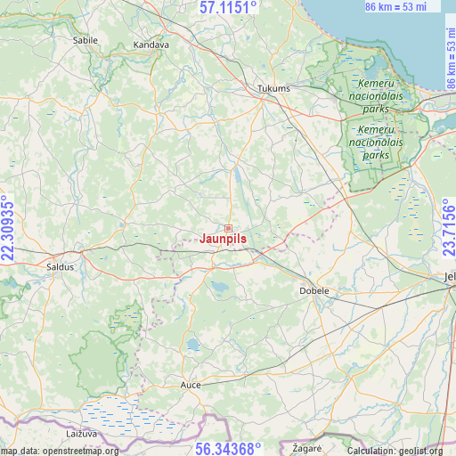
Jaunpils GPS coordinates[2]
56° 43' 52.932" North, 23° 0' 44.892" East
| Map corner | latitude | longitude |
|---|---|---|
| Upper-left | 57.1151°, | 22.30935° |
| Center: | 56.73137°, | 23.01247° |
| Lower-right: | 56.34368°, | 23.7156° |
| Map W x H: | 85.8×85.8 km | = 53.3×53.3mi |
| max Lat: | 57.89752° ⇑61.4% North |
| Jaunpils: | 56.73137° |
| min Lat: | ⇓38.6% South 55.75284° |
| min Long | Jaunpils | max Long |
| 21.01085° | 23.01247° | 28.12165° |
| W 18.6%⇐ | ⇒81.4% E |
Elevation
Elevation of Jaunpils is 72 m = 236 ft, and this is 6.6 m = 22 ft above average elevation for this country.
| Max E: |
212 m = 696 ft | 42.1% |
| Jaunpils | 72 m 236 ft | |
| Avg. | 65.4 m = 215 ft | |
Min E: |
2 m = 7 ft | 57.9% |
See also: Latvia elevation on elevation.city.
Geographical zone
Jaunpils is located in North temperate zone (between Tropic of Cancer and the Arctic Circle). Distance of this North polar circle is 1093.2 km =679.3 mi to North.| Distance of | km | miles | from Jaunpils |
|---|---|---|---|
| North Pole | 3699.1 | 2298.5 | to North |
| Arctic Circle | 1093.2 | 679.3 | to North |
| Tropic Cancer | 3702 | 2300.3 | to South |
| Equator | 6307.9 | 3919.5 | to South |


Nearby cities:
15 places around Jaunpils: (largest is in red/bold)
• Auce
30.9 km =19.2 mi,  192°
192°
• Brocēni
27.7 km =17.2 mi,  257°
257°
• Dobele
20 km =12.4 mi,  126°
126°
• Jelgava
43.7 km =27.2 mi,  101°
101°
• Kandava
37.3 km =23.2 mi,  337°
337°
• Milzkalne
30.3 km =18.8 mi,  25°
25°
• Ozolnieki
46.8 km =29.1 mi, 95°
• Ragaciems
43.7 km =27.2 mi,  42°
42°
• Sabile
44 km =27.3 mi,  322°
322°
• Saldus
32.9 km =20.4 mi, 256°
• Smārde
31.7 km =19.7 mi, 38°
• Tukums
27.7 km =17.2 mi,  18°
18°
• Tērvete
36.2 km =22.5 mi,  140°
140°
• Tīreļi
37.1 km =23.1 mi,  71°
71°
• Zelmeņi
37.4 km =23.2 mi,  146°
146°
Sources, notices
• [Note1] Compared only with cities in Latvia existing in our database
• [Src1] Map data: © OpenStreetMap contributors (CC-BY-SA)
• [Src2] Other city data from geonames.org with taken over terms of usage.
• [Src3] Geographical zone / Annual Mean Temperature by Robert A. Rohde @ Wikipedia
