Stende geodata
Stende (Talsi Municipality) is a populated place; located in Latvia in Europe/Riga (GMT+3) time zone. With population of 1,955 people, there are 75 cities with bigger population in this country. Compared to other cities in Latvia, 72.1% of cities are located further ↓South; 87.1% of cities are located further →East and 67.9% of cities have lower elevation than Stende. Note1


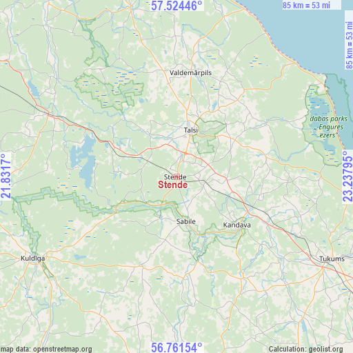
Stende GPS coordinates[2]
57° 8' 41.892" North, 22° 32' 5.352" East
| Map corner | latitude | longitude |
|---|---|---|
| Upper-left | 57.52446°, | 21.8317° |
| Center: | 57.14497°, | 22.53482° |
| Lower-right: | 56.76154°, | 23.23795° |
| Map W x H: | 84.8×84.8 km | = 52.7×52.7mi |
| max Lat: | 57.89752° ⇑27.9% North |
| Stende: | 57.14497° |
| min Lat: | ⇓72.1% South 55.75284° |
| min Long | Stende | max Long |
| 21.01085° | 22.53482° | 28.12165° |
| W 12.9%⇐ | ⇒87.1% E |
Elevation
Elevation of Stende is 91 m = 299 ft, and this is 25.6 m = 84 ft above average elevation for this country.
| Max E: |
212 m = 696 ft | 32.1% |
| Stende | 91 m 299 ft | |
| Avg. | 65.4 m = 215 ft | |
Min E: |
2 m = 7 ft | 67.9% |
See also: Latvia elevation on elevation.city.
Geographical zone
Stende is located in North temperate zone (between Tropic of Cancer and the Arctic Circle). Distance of this North polar circle is 1047.2 km =650.7 mi to North.| Distance of | km | miles | from Stende |
|---|---|---|---|
| North Pole | 3653.1 | 2269.9 | to North |
| Arctic Circle | 1047.2 | 650.7 | to North |
| Tropic Cancer | 3748 | 2328.9 | to South |
| Equator | 6353.9 | 3948.1 | to South |


Nearby cities:
15 places around Stende: (largest is in red/bold)
• Brocēni
51.9 km =32.2 mi,  177°
177°
• Dundaga
41.5 km =25.8 mi,  344°
344°
• Engure
41.7 km =25.9 mi,  87°
87°
• Kandava
18.5 km =11.5 mi,  128°
128°
• Kuldīga
39.8 km =24.7 mi,  241°
241°
• Milzkalne
45.7 km =28.4 mi,  114°
114°
• Mērsrags
41.3 km =25.7 mi,  59°
59°
• Piltene
52.6 km =32.7 mi,  279°
279°
• Roja
42.9 km =26.7 mi,  22°
22°
• Sabile
11.3 km =7 mi,  168°
168°
• Smārde
53 km =32.9 mi, 113°
• Talsi
11.5 km =7.1 mi,  14°
14°
• Tukums
42.4 km =26.3 mi,  117°
117°
• Valdemārpils
25.3 km =15.7 mi, 7°
• Ēdole
52.8 km =32.8 mi,  254°
254°
Sources, notices
• [Note1] Compared only with cities in Latvia existing in our database
• [Src1] Map data: © OpenStreetMap contributors (CC-BY-SA)
• [Src2] Other city data from geonames.org with taken over terms of usage.
• [Src3] Geographical zone / Annual Mean Temperature by Robert A. Rohde @ Wikipedia
