Sidi Bou Othmane geodata
Sidi Bou Othmane (Marrakesh-Safi) is a seat of a third-order administrative division; located in Morocco in Africa/Casablanca (GMT+1) time zone. In our database, there are 108 cities with bigger population. Compared to other cities in Morocco, 67.1% of cities are located further ↑North; 77.1% of cities are located further →East and 52.3% of cities have lower elevation than Sidi Bou Othmane. Note1
Administrative division(s):
- Level 1: Marrakesh-Safi
- Level 2: Kelaa-Des-Sraghna
- Level 3: Sidi Bou Othmane


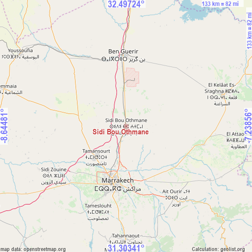
Sidi Bou Othmane GPS coordinates[2]
31° 54' 8.136" North, 7° 56' 30.084" West
| Map corner | latitude | longitude |
|---|---|---|
| Upper-left | 32.49724°, | -8.64481° |
| Center: | 31.90226°, | -7.94169° |
| Lower-right: | 31.30341°, | -7.23856° |
| Map W x H: | 132.7×132.7 km | = 82.5×82.5mi |
| max Lat: | 35.84906° ⇑67.1% North |
| Sidi Bou Othmane: | 31.90226° |
| min Lat: | ⇓32.9% South 22.6558° |
| min Long | Sidi Bou Othman | max Long |
| -15.60719° | -7.94169° | -1.22855° |
| W 22.9%⇐ | ⇒77.1% E |
Elevation
Elevation of Sidi Bou Othmane is 513 m = 1683 ft, and this is 103.8 m = 341 ft below average elevation for this country.
| Max E: |
2637 m = 8652 ft | 47.7% |
| Avg. | 616.8 m = 2024 ft | |
| Sidi Bou Othmane | 513 m = 1683 ft | |
Min E: |
1 m = 3 ft | 52.3% |
See also: Morocco elevation on elevation.city.
Geographical zone
Sidi Bou Othmane is located in North temperate zone (between Tropic of Cancer and the Arctic Circle). Distance of this Northern Tropic circle is 941.3 km =584.9 mi to South.| Distance of | km | miles | from Sidi Bou Othmane |
|---|---|---|---|
| North Pole | 6459.9 | 4014 | to North |
| Arctic Circle | 3854 | 2394.8 | to North |
| Tropic Cancer | 941.3 | 584.9 | to South |
| Equator | 3547.2 | 2204.1 | to South |


Nearby cities:
15 places around Sidi Bou Othmane: (largest is in red/bold)
• Abadou
69.5 km =43.2 mi,  121°
121°
• Amizmiz
81 km =50.3 mi,  199°
199°
• Marrakesh
30.3 km =18.8 mi,  190°
190°
• Moulay Brahim
68.4 km =42.5 mi,  182°
182°
• Oukaïmedene
77.8 km =48.3 mi,  174°
174°
• Setti Fatma
79.3 km =49.3 mi,  161°
161°
• Sidi Abdallah
71.1 km =44.2 mi,  8°
8°
• Sidi Abdallah Ghiat
43.4 km =27 mi, 166°
• Sidi Moussa
81 km =50.3 mi,  59°
59°
• Sidi Rahhal
52.4 km =32.6 mi, 122°
• Tidili Mesfioua
57.7 km =35.9 mi,  147°
147°
• Tizguine
82.9 km =51.5 mi,  205°
205°
• Touama
58.9 km =36.6 mi,  133°
133°
• Youssoufia
67.3 km =41.8 mi,  304°
304°
• Zerkten
72.7 km =45.2 mi, 134°
Sources, notices
• [Note1] Compared only with cities in Morocco existing in our database
• [Src1] Map data: © OpenStreetMap contributors (CC-BY-SA)
• [Src2] Other city data from geonames.org with taken over terms of usage.
• [Src3] Geographical zone / Annual Mean Temperature by Robert A. Rohde @ Wikipedia
