Oukaïmedene geodata
Oukaïmedene (Marrakesh-Safi) is a populated place; located in Morocco in Africa/Casablanca (GMT+1) time zone. With population of 4,440 people, there are 97 cities with bigger population in this country. Compared to other cities in Morocco, 80.2% of cities are located further ↑North; 76% of cities are located further →East and 100% of cities have lower elevation than Oukaïmedene. Note1


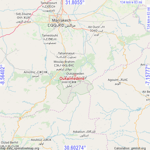
Oukaïmedene GPS coordinates[2]
31° 12' 21.708" North, 7° 51' 39.204" West
| Map corner | latitude | longitude |
|---|---|---|
| Upper-left | 31.8055°, | -8.56402° |
| Center: | 31.20603°, | -7.86089° |
| Lower-right: | 30.60274°, | -7.15777° |
| Map W x H: | 133.7×133.7 km | = 83.1×83.1mi |
| max Lat: | 35.84906° ⇑80.2% North |
| Oukaïmedene: | 31.20603° |
| min Lat: | ⇓19.8% South 22.6558° |
| min Long | Oukaïmedene | max Long |
| -15.60719° | -7.86089° | -1.22855° |
| W 24%⇐ | ⇒76% E |
Elevation
Elevation of Oukaïmedene is 2637 m = 8652 ft, and this is 2020.2 m = 6628 ft above average elevation for this country.
| Max E: |
2637 m = 8652 ft | 0% |
| Oukaïmedene | 2637 m 8652 ft | |
| Avg. | 616.8 m = 2024 ft | |
Min E: |
1 m = 3 ft | 100% |
See also: Morocco elevation on elevation.city.
Geographical zone
Oukaïmedene is located in North temperate zone (between Tropic of Cancer and the Arctic Circle). Distance of this Northern Tropic circle is 863.9 km =536.8 mi to South.| Distance of | km | miles | from Oukaïmedene |
|---|---|---|---|
| North Pole | 6537.3 | 4062.1 | to North |
| Arctic Circle | 3931.4 | 2442.9 | to North |
| Tropic Cancer | 863.9 | 536.8 | to South |
| Equator | 3469.8 | 2156 | to South |


Nearby cities:
15 places around Oukaïmedene: (largest is in red/bold)
• Adassil
60.9 km =37.8 mi,  259°
259°
• Amerzgane
64.5 km =40.1 mi,  106°
106°
• Amizmiz
35.3 km =21.9 mi,  271°
271°
• Azgour
43.9 km =27.3 mi, 259°
• Iguidi
41.1 km =25.5 mi,  185°
185°
• Marrakesh
49.4 km =30.7 mi,  344°
344°
• Moulay Brahim
13.7 km =8.5 mi,  311°
311°
• Setti Fatma
17.6 km =10.9 mi,  83°
83°
• Sidi Abdallah Ghiat
35.3 km =21.9 mi,  4°
4°
• Sidi Rahhal
61.6 km =38.3 mi,  36°
36°
• Telouet
59.9 km =37.2 mi, 81°
• Tidili Mesfioua
37.3 km =23.2 mi, 39°
• Tizguine
43.4 km =27 mi, 273°
• Touama
50.6 km =31.4 mi, 43°
• Zerkten
51.8 km =32.2 mi,  59°
59°
Sources, notices
• [Note1] Compared only with cities in Morocco existing in our database
• [Src1] Map data: © OpenStreetMap contributors (CC-BY-SA)
• [Src2] Other city data from geonames.org with taken over terms of usage.
• [Src3] Geographical zone / Annual Mean Temperature by Robert A. Rohde @ Wikipedia
