Touama geodata
Touama (Marrakesh-Safi) is a seat of a third-order administrative division; located in Morocco in Africa/Casablanca (GMT+1) time zone. In our database, there are 108 cities with bigger population. Compared to other cities in Morocco, 72.5% of cities are located further ↑North; 70.5% of cities are located further →East and 73.3% of cities have lower elevation than Touama. Note1


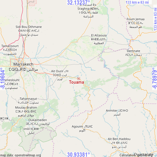
Touama GPS coordinates[2]
31° 32' 6.036" North, 7° 29' 34.476" West
| Map corner | latitude | longitude |
|---|---|---|
| Upper-left | 32.13237°, | -8.19604° |
| Center: | 31.53501°, | -7.49291° |
| Lower-right: | 30.93381°, | -6.78979° |
| Map W x H: | 133.3×133.3 km | = 82.8×82.8mi |
| max Lat: | 35.84906° ⇑72.5% North |
| Touama: | 31.53501° |
| min Lat: | ⇓27.5% South 22.6558° |
| min Long | Touama | max Long |
| -15.60719° | -7.49291° | -1.22855° |
| W 29.5%⇐ | ⇒70.5% E |
Elevation
Elevation of Touama is 950 m = 3117 ft, and this is 333.2 m = 1093 ft above average elevation for this country.
| Max E: |
2637 m = 8652 ft | 26.7% |
| Touama | 950 m 3117 ft | |
| Avg. | 616.8 m = 2024 ft | |
Min E: |
1 m = 3 ft | 73.3% |
See also: Morocco elevation on elevation.city.
Geographical zone
Touama is located in North temperate zone (between Tropic of Cancer and the Arctic Circle). Distance of this Northern Tropic circle is 900.4 km =559.5 mi to South.| Distance of | km | miles | from Touama |
|---|---|---|---|
| North Pole | 6500.7 | 4039.3 | to North |
| Arctic Circle | 3894.8 | 2420.1 | to North |
| Tropic Cancer | 900.4 | 559.5 | to South |
| Equator | 3506.4 | 2178.8 | to South |


Nearby cities:
15 places around Touama: (largest is in red/bold)
• Abadou
17.7 km =11 mi,  73°
73°
• Amerzgane
60.9 km =37.8 mi,  153°
153°
• Bzou
74.8 km =46.5 mi,  34°
34°
• Demnate
51.2 km =31.8 mi,  64°
64°
• Marrakesh
49.3 km =30.6 mi,  282°
282°
• Moulay Brahim
52.8 km =32.8 mi,  238°
238°
• Oukaïmedene
50.6 km =31.4 mi,  223°
223°
• Setti Fatma
38.7 km =24 mi,  206°
206°
• Sidi Abdallah Ghiat
32.3 km =20.1 mi,  267°
267°
• Sidi Bou Othmane
58.9 km =36.6 mi,  313°
313°
• Sidi Rahhal
13 km =8.1 mi,  8°
8°
• Telouet
36.5 km =22.7 mi,  138°
138°
• Tidili Mesfioua
13.7 km =8.5 mi, 235°
• Tifni
53.3 km =33.1 mi,  78°
78°
• Zerkten
13.9 km =8.6 mi, 136°
Sources, notices
• [Note1] Compared only with cities in Morocco existing in our database
• [Src1] Map data: © OpenStreetMap contributors (CC-BY-SA)
• [Src2] Other city data from geonames.org with taken over terms of usage.
• [Src3] Geographical zone / Annual Mean Temperature by Robert A. Rohde @ Wikipedia
