Selouane geodata
Selouane (Oriental) is a seat of a third-order administrative division; located in Morocco in Africa/Casablanca (GMT+1) time zone. In our database, there are 108 cities with bigger population. Compared to other cities in Morocco, 89.1% of cities are located further ↓South; 92.2% of cities are located further ←West and 81.4% of cities have higher elevation than Selouane. Note1


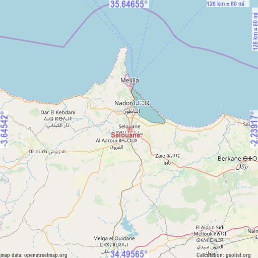
Selouane GPS coordinates[2]
35° 4' 23.268" North, 2° 56' 32.28" West
| Map corner | latitude | longitude |
|---|---|---|
| Upper-left | 35.64655°, | -3.64542° |
| Center: | 35.07313°, | -2.9423° |
| Lower-right: | 34.49565°, | -2.23917° |
| Map W x H: | 128×128 km | = 79.5×79.5mi |
| max Lat: | 35.84906° ⇑10.9% North |
| Selouane: | 35.07313° |
| min Lat: | ⇓89.1% South 22.6558° |
| min Long | Selouane | max Long |
| -15.60719° | -2.9423° | -1.22855° |
| W 92.2%⇐ | ⇒7.8% E |
Elevation
Elevation of Selouane is 80 m = 262 ft, and this is 536.8 m = 1761 ft below average elevation for this country.
| Max E: |
2637 m = 8652 ft | 81.4% |
| Avg. | 616.8 m = 2024 ft | |
| Selouane | 80 m = 262 ft | |
Min E: |
1 m = 3 ft | 18.6% |
See also: Morocco elevation on elevation.city.
Geographical zone
Selouane is located in North temperate zone (between Tropic of Cancer and the Arctic Circle). Distance of this Northern Tropic circle is 1293.8 km =803.9 mi to South.| Distance of | km | miles | from Selouane |
|---|---|---|---|
| North Pole | 6107.3 | 3794.9 | to North |
| Arctic Circle | 3501.4 | 2175.7 | to North |
| Tropic Cancer | 1293.8 | 803.9 | to South |
| Equator | 3899.8 | 2423.2 | to South |


Nearby cities:
15 places around Selouane: (largest is in red/bold)
• Al Aaroui
9.2 km =5.7 mi,  221°
221°
• Berkane
59.2 km =36.8 mi,  106°
106°
• Boudinar
62.6 km =38.9 mi,  278°
278°
• El Aïoun
67.5 km =41.9 mi,  143°
143°
• Hassi Berkane
26.9 km =16.7 mi,  165°
165°
• Kariat Arkmane
18.2 km =11.3 mi,  78°
78°
• Madagh
55.5 km =34.5 mi,  97°
97°
• Midar
55.8 km =34.7 mi,  254°
254°
• Mosquée
56.6 km =35.2 mi,  121°
121°
• Nador
10.6 km =6.6 mi,  4°
4°
• Rislane
55.4 km =34.4 mi,  127°
127°
• Saidia
64.9 km =40.3 mi,  89°
89°
• Taouima
6.4 km =4 mi,  11°
11°
• Tiztoutine
22.2 km =13.8 mi,  239°
239°
• Zaïo
24 km =14.9 mi, 127°
Sources, notices
• [Note1] Compared only with cities in Morocco existing in our database
• [Src1] Map data: © OpenStreetMap contributors (CC-BY-SA)
• [Src2] Other city data from geonames.org with taken over terms of usage.
• [Src3] Geographical zone / Annual Mean Temperature by Robert A. Rohde @ Wikipedia
