Berkane geodata
Berkane (Oriental) is a seat of a third-order administrative division; located in Morocco in Africa/Casablanca (GMT+1) time zone. With population of 80,721 people, there are 31 cities with bigger population in this country. Compared to other cities in Morocco, 83.7% of cities are located further ↓South; 96.5% of cities are located further ←West and 75.2% of cities have higher elevation than Berkane. Note1


Berkane GPS coordinates[2]
34° 55' 12" North, 2° 19' 12" West
| Map corner | latitude | longitude |
|---|---|---|
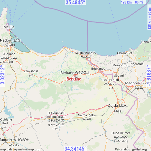
| Upper-left | 35.4945°, | -3.02312° |
| Center: | 34.92°, | -2.32° |
| Lower-right: | 34.34145°, | -1.61687° |
| Map W x H: | 128.2×128.2 km | = 79.7×79.7mi |
| max Lat: | 35.84906° ⇑16.3% North |
| Berkane: | 34.92° |
| min Lat: | ⇓83.7% South 22.6558° |
| min Long | Berkane | max Long |
| -15.60719° | -2.32° | -1.22855° |
| W 96.5%⇐ | ⇒3.5% E |
Elevation
Elevation of Berkane is 173 m = 568 ft, and this is 443.8 m = 1456 ft below average elevation for this country.
| Max E: |
2637 m = 8652 ft | 75.2% |
| Avg. | 616.8 m = 2024 ft | |
| Berkane | 173 m = 568 ft | |
Min E: |
1 m = 3 ft | 24.8% |
See also: Berkane elevation on elevation.city.
Geographical zone
Berkane is located in North temperate zone (between Tropic of Cancer and the Arctic Circle). Distance of this Northern Tropic circle is 1276.8 km =793.4 mi to South.| Distance of | km | miles | from Berkane |
|---|---|---|---|
| North Pole | 6124.3 | 3805.5 | to North |
| Arctic Circle | 3518.4 | 2186.2 | to North |
| Tropic Cancer | 1276.8 | 793.4 | to South |
| Equator | 3882.7 | 2412.6 | to South |


Nearby cities:
15 places around Berkane: (largest is in red/bold)
• Ahfir
20.4 km =12.7 mi,  79°
79°
• Al Aaroui
63.6 km =39.5 mi,  279°
279°
• El Aïoun
41.1 km =25.5 mi,  204°
204°
• Guenfouda
54.6 km =33.9 mi,  152°
152°
• Hassi Berkane
50.7 km =31.5 mi,  259°
259°
• Kariat Arkmane
44.1 km =27.4 mi,  298°
298°
• Madagh
10.2 km =6.3 mi,  351°
351°
• Mosquée
15.2 km =9.4 mi,  213°
213°
• Nador
62.3 km =38.7 mi, 296°
• Oujda-Angad
46 km =28.6 mi,  125°
125°
• Rislane
21 km =13 mi,  217°
217°
• Saidia
19.8 km =12.3 mi,  24°
24°
• Selouane
59.2 km =36.8 mi,  286°
286°
• Taouima
60.1 km =37.3 mi, 292°
• Zaïo
37.7 km =23.4 mi,  273°
273°
Sources, notices
• [Note1] Compared only with cities in Morocco existing in our database
• [Src1] Map data: © OpenStreetMap contributors (CC-BY-SA)
• [Src2] Other city data from geonames.org with taken over terms of usage.
• [Src3] Geographical zone / Annual Mean Temperature by Robert A. Rohde @ Wikipedia
