Boudinar geodata
Boudinar (Oriental) is a seat of a third-order administrative division; located in Morocco in Africa/Casablanca (GMT+1) time zone. In our database, there are 108 cities with bigger population. Compared to other cities in Morocco, 92.6% of cities are located further ↓South; 89.9% of cities are located further ←West and 68.6% of cities have higher elevation than Boudinar. Note1


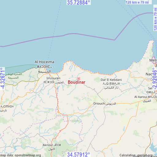
Boudinar GPS coordinates[2]
35° 9' 21.636" North, 3° 37' 24.888" West
| Map corner | latitude | longitude |
|---|---|---|
| Upper-left | 35.72884°, | -4.32671° |
| Center: | 35.15601°, | -3.62358° |
| Lower-right: | 34.57912°, | -2.92046° |
| Map W x H: | 127.8×127.8 km | = 79.4×79.4mi |
| max Lat: | 35.84906° ⇑7.4% North |
| Boudinar: | 35.15601° |
| min Lat: | ⇓92.6% South 22.6558° |
| min Long | Boudinar | max Long |
| -15.60719° | -3.62358° | -1.22855° |
| W 89.9%⇐ | ⇒10.1% E |
Elevation
Elevation of Boudinar is 239 m = 784 ft, and this is 377.8 m = 1240 ft below average elevation for this country.
| Max E: |
2637 m = 8652 ft | 68.6% |
| Avg. | 616.8 m = 2024 ft | |
| Boudinar | 239 m = 784 ft | |
Min E: |
1 m = 3 ft | 31.4% |
See also: Morocco elevation on elevation.city.
Geographical zone
Boudinar is located in North temperate zone (between Tropic of Cancer and the Arctic Circle). Distance of this Northern Tropic circle is 1303.1 km =809.7 mi to South.| Distance of | km | miles | from Boudinar |
|---|---|---|---|
| North Pole | 6098.1 | 3789.2 | to North |
| Arctic Circle | 3492.2 | 2170 | to North |
| Tropic Cancer | 1303.1 | 809.7 | to South |
| Equator | 3909 | 2428.9 | to South |


Nearby cities:
15 places around Boudinar: (largest is in red/bold)
• Ajdir
56 km =34.8 mi,  214°
214°
• Aknoul
60.1 km =37.3 mi,  201°
201°
• Al Aaroui
58.2 km =36.2 mi,  106°
106°
• Al Hoceïma
30.4 km =18.9 mi,  290°
290°
• Bni Bouayach
20.5 km =12.7 mi,  253°
253°
• Imzouren
20.7 km =12.9 mi,  267°
267°
• Midar
25.4 km =15.8 mi,  161°
161°
• Nador
62.7 km =39 mi,  88°
88°
• Rouadi
46.6 km =29 mi, 267°
• Selouane
62.6 km =38.9 mi,  98°
98°
• Senada
54.6 km =33.9 mi,  260°
260°
• Taouima
63.3 km =39.3 mi, 92°
• Targuist
67.8 km =42.1 mi, 249°
• Tirhanimîne
31.4 km =19.5 mi, 286°
• Tiztoutine
47.5 km =29.5 mi,  115°
115°
Sources, notices
• [Note1] Compared only with cities in Morocco existing in our database
• [Src1] Map data: © OpenStreetMap contributors (CC-BY-SA)
• [Src2] Other city data from geonames.org with taken over terms of usage.
• [Src3] Geographical zone / Annual Mean Temperature by Robert A. Rohde @ Wikipedia
